
One of the most fascinating subjects I personally keep returning to is the area around the Gulf of Mexico and that point in Earth’s history when she was hit by a massive asteroid and the millions of years of global non avian dinosaur existence came to an end. I’ve written blogs previously, dipping into findings from books and online, to research ongoing history of that most cursed and blessed location.
Beginning with the impact of a large meteorite, at the site of Chicxulub Crater, just west of Mexico’s Yucatan Peninsula, researchers noted higher levels of iridium at the Cretaceous–Paleogene boundary (K–Pg boundary), (see Alvarez Nobel Prize winning hypothesis, 1980, https://en.m.wikipedia.org/wiki/Cretaceous–Paleogene_boundary) which occurred approximately 65 to 66 million years ago (Ma). This extinction event resulted in 75 percent extinction of animal and plant species in a geologically short period of time, recorded in studies of the sediment from the point of the crater to areas around the world.
In addition to finding increased levels of iridium, recent research of the asteroid sent carbon, embedded in the rocks, vaporising due to the impact, forming tiny airborne beads (carbon structures) that blanketed the planet. This was discovered in 2008 by Indiana University Bloomington geologist Simon Brassell, study coauthor and former adviser to the paper’s lead author, Mark Harvey. The scientists concluded the cenospheres could have been created by a new process, the violent pulverization of the Earth’s carbon-rich crust.
Scientists now estimate the total mass of carbon cenospheres ejected by the asteroid collision, assuming a global distribution, to be perhaps as much as 900 quadrillion kilograms. Only animals underground and creatures underwater could have survived when the air burned so hot.
In 2018, scientists are warning that the earth is heating up to the level where we, who have flagrantly sought and burned fossil fuels, are close to the brink of a further 2 degree increase in temperature which will be the tipping point from which we can no longer save ourselves. The sixth extinction will begin.
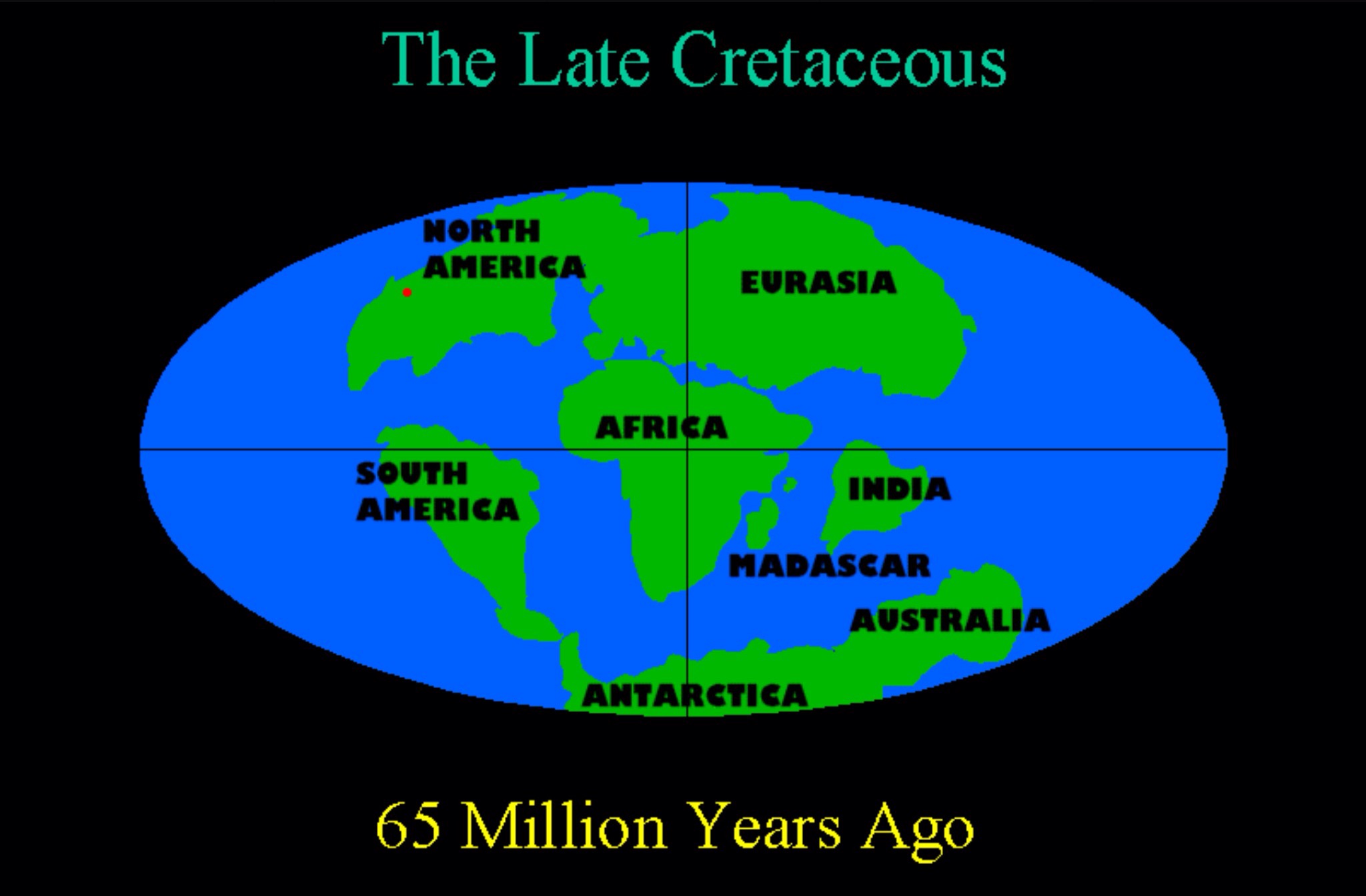
Map of earth 66 million years ago
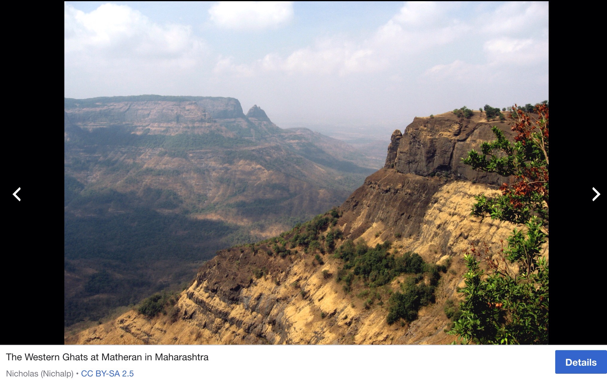
Around the same time as the asteroid hit, the largest volcanic range in the world was erupting – the Deccan traps in India.
Image of Deccan Traps
Here is an extract from information on the volcanic Deccan Traps in India, https://en.m.wikipedia.org/wiki/Deccan_Traps
“In addition, there is some evidence to link the Deccan Traps eruption to the asteroid impact which created the Chicxulub crater in the Mexican state of Yucatán. Although the Deccan Traps began erupting well before the impact, argon-argon dating suggests that the impact may have caused an increase in permeability that allowed magma to reach the surface and produced the most voluminous flows, accounting for around 70% of the volume. The combination of the asteroid impact and the resulting increase in eruptive volume may have been responsible for the mass extinctions that occurred at the time that separates the Cretaceous and Paleogene periods, known as the K–Pg boundary.”
The land-living dinosaurs were destroyed but they were victims of a perfect storm; a devastating meteorite hitting the worst ever point on Earth, and volcanic eruptions of the Deccan Traps concurrently occurring.
But we humans have been on Earth for a blip of time compared to the lumbering dinosaurs. We know Africa has the longest record of human habitation in the world since the first hominins emerged, but that was just 6-7 million years ago. Whilst our ancestors evolved, the earth changed what it had to offer for humans to adapt or die as they took on the challenge to survive. Over time, Homo sapiens had acquired adaptive abilities to survive in many friendly but also seemingly hostile environments. Their genetics and interbreeding passed on protections from disease, skills for survival and abilities to assess new situations and environments. Our adaptable nature seems like a great asset, but the Earth has been plundered by us again and again as we expect more and more from its bounty. We see threats – we turn them into opportunities. We see volcanoes, yet we live close to them. (Fossils of early hominins were found in the East Rift Valley – a volcanic area, see an earlier blog https://borderslynn.com/2018/02/19/the-great-rift-valley-route-out-to-world-exploration/)
Volcanoes are
….generally found where tectonic plates are diverging or converging, and most are found underwater. For example, a mid-oceanic ridge, such as the Mid-Atlantic Ridge, has volcanoes caused by divergent tectonic plates whereas the Pacific Ring of Fire has volcanoes caused by convergent tectonic plates. Volcanoes can also form where there is stretching and thinning of the crust’s plates, e.g., in the East African Rift and the Wells Gray-Clearwater volcanic field and Rio Grande Rift in North America. This type of volcanism falls under the umbrella of ‘plate hypothesis’ volcanism. Volcanism away from plate boundaries has also been explained as mantle plumes. These so-called ‘hotspots’, for example Hawaii, are postulated to arise from upwelling diapirs with magma from the core–mantle boundary, 3,000 km deep in the Earth. Volcanoes are usually not created where two tectonic plates slide past one another. Extract from https://en.m.wikipedia.org/wiki/Volcano.
Most volcanoes are located along the Pacific Ring of Fire, where tectonic plates can slide beneath one another and cause a disturbance. We have only learned about tectonic plates in the past 60 years. In 1912 the meteorologist Alfred Wegener amply described what he called continental drift, expanded in his 1915 book The Origin of Continents and Oceans, and the scientific debate started that would end up fifty years later in the theory of plate tectonics.
The size of the volcano eruption depends on how much time a volcano has had to build up pressure — some of the biggest volcano disasters came after a long period of dormancy.
Early August 2018 saw the 6.9 mag earthquake hit the Indonesian islands in the Pacific of Bali, Lombok and islands nearby.
A supervolcano eruption about 74,000 years ago on Indonesia’s island of Sumatra caused a large-scale environmental calamity that may have decimated Stone Age human populations in parts of the world. But some populations, it seems, endured it unscathed.
Scientists said excavations at two nearby archeological sites on South Africa’s southern coast turned up microscopic shards of volcanic glass from the Mount Toba eruption, which occurred about 9,000 kilometres away.
Mount Toba belched immense amounts of volcanic particles into the atmosphere to spread worldwide, dimming sunlight and potentially killing many plants. It was the most powerful eruption in the past two million years and the strongest since our species first appeared in Africa.
Hawaii’s largest island has been devastated by the volcano Kilauea, the biggest and most active of the island’s five volcanoes and is one of the most active in the world. It is situated on the southern shore of Hawaii’s “Big Island”. It has been erupting consistently since 1983 after a period of being dormant. Yet beautiful homes have been built in its shadow and farming has been extensive because of fertile soils. Now much is covered beneath foul smelling, burning lava.
Timeline of events from May 3,2018
May 3, 2018: The volcano erupted dramatically several hours after a magnitude-5.0 quake struck the Big Island.
The eruption spewed lava into residential subdivisions in the Puna district of the Big Island, prompting mandatory evacuations of the Leilani Estates and Lanipuna Gardens subdivisions
Lava flow on May 3 was caused by a series of earthquakes on the eastern side of the Big Island
The island’s largest earthquake in more than 40 years struck a day later on May 4
The magnitude 6.9 tremor hit near the south part of the volcano, following a smaller quake that rattled the same area
May 12: The USGS reported a shallow but small earthquake with a magnitude of 3.5 had struck the island
May 13: New fissures roaring like jet engines and spewing magma opened up, piling lava as high as a four-story building
The 300m long crack is the 17th to have opened since the volcano began erupting
Locals say 45kg chunks of lava were hurled into the air as smoke and steam spewed into the air
May 15: Rumours circulated suggesting the volcano could cause a “mega-tsunami” – these claims were refuted by Hawaii County officials
May 16: Plumes of between 3,000 to 6,000 feet rose from the volcano
The Hawaiian Electric Company restored power to all 571 customers in Aiea affected by a power outage on the morning
May 17: The volcano erupted sending a plume of ash six miles into the air – Kilauea was also blasting out “ballistic blocks” the size of kitchen appliances
May 20: A man was injured by “lava splatter” – projectile molten rock – whilst he sat on his balcony
May 25: A 4.4 magnitude earthquake struck near the summit of Kilauea, according to the US Geological Survey
June 3: A 5.5 magnitude earthquake rattled the summit of Kilauea sending an ash plume 8,000 feet into the sky, officials said.
The huge quake was one of 500 in the summit area in a 24 hour period – which is a record for the Hawaiian volcano
June 5: A growing river of molten rock flowing from a fissure at the foot of the volcano is believed to have demolished scores of additional homes.
The latest estimates – up to 80 more structures – could bring the total number of homes and other buildings lost over the past month to nearly 200.
The massive lava flow has filled in a small bay at the eastern tip of Hawaii’s Big Island, civil defence officials said.
June 18: Lava continued to spew out of the volcano. More than 600 homes are believed to be destroyed by the violent eruptions.
July 16: Lava bomb sent molten rock crashing through tourist boat injuring 23 following another eruption
This description illustrates the human vulnerability to Nature and explains why humans have always been drawn to the magnificence of such power contrasted at the same moment with pure terror experienced by many who flee for the lives.
When the land masses of South America collided with the land mass which we now call North America, the Atlantic and the Pacific oceans were created, separating a much larger ocean in two and the land bridge (Panama) allowed land animals to move between North and South. This event occurred 2.8 million years ago, not long after what we refer to as the beginning of the dramatic Pleistocene, 2.5 million years BP. This area is a tectonic plate meeting point.
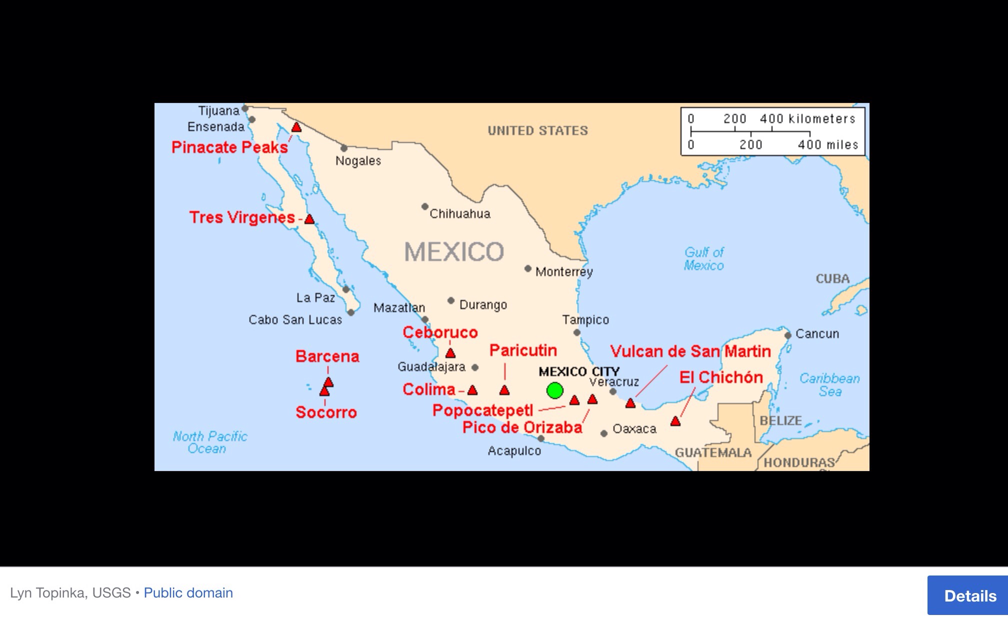
Almost all of Mexico sits atop the south-west corner of the massive North American plate (see map). Immediately to the south is the much smaller Caribbean plate. The North American plate extends westwards from the Mid-Atlantic Ridge, which runs through Iceland and down the middle of the Atlantic Ocean, to the western edge of North America. In a north-south direction, it extends from close to the North Pole as far south as the Caribbean.
For more details see http://geo-mexico.com/?p=6277
Image of major Six Mexican Volcanoes which form the volcanic axis:
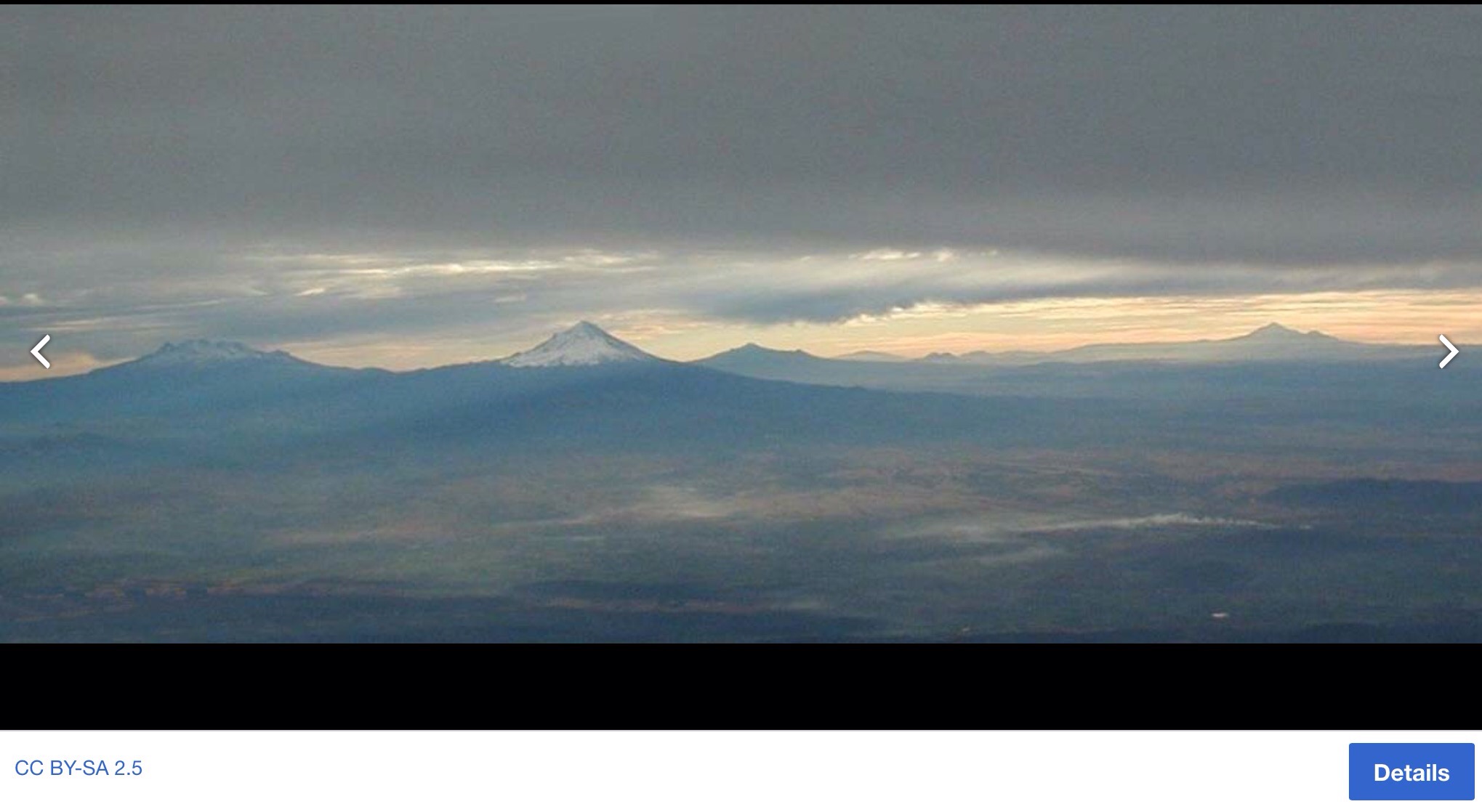
Left to right Ixtaccíhuatl, Popocatépetl, Matlalcueitl (Malinche), Cofre de Perote (most distant), Pico de Orizaba, Sierra Negra
Map of Mexico and volcanic sites
And map of obsidian sites

Since the Stone Age skills acquired by humans were extensive by the time the Osmec and Lapita cultures developed. Amongst other skills, they were by now adept at making tools, some of which were used to carve sophisticated and huge statues from the volcanic rock. Volcanic basalt rock is easier to carve than many other forms of rock. See my earlier blog on carved heads from basalt in Mexico, Easter Island at https://borderslynn.com/2017/11/19/mesoamerican-cradle-of-civilisation-and-the-osmec-head-sculptures/
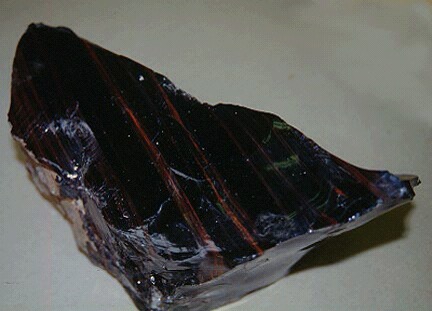
Obsidian was valued in Stone Age cultures because, like flint, it could be chipped to produce hand axes, sharp blades or arrowheads.
Pre-Columbian Mesoamericans’ used obsidian often. It was worked for tools and decorative objects. It was also polished to create early mirrors. Mesoamericans also made a type of sword with obsidian blades mounted in a wooden body. Called a macuahuitl, the weapon could cause terrible injuries, because it combined the sharp cutting edge of an obsidian blade with the ragged cut of a serrated edge.
Native American people traded obsidian throughout North America. Each volcano and in some cases each volcanic eruption produces a distinguishable type of obsidian. So archaeologists can trace the origins of a particular artifact. Obsidian can be identified in Greece as coming from different islands in the Aegean Sea. Obsidian cores (unworked lumps) and blades were traded great distances inland from the coast.
Obsidian was named after a Roman explorer named Obsius who reportedly visited Ethiopia. His name serves as the origin of the term since his discovery of its use whilst on his travels in Ethiopia where obsidian was traded.
Obsidian is more often dark, the colour varies on the presence of different materials. Iron and magnesium typically give the obsidian a dark green to brown to black color. A few samples are nearly colorless. In some stones, small crystals produce a snowflake pattern (snowflake obsidian). It may contain patterns of gas which produce effects such as a golden sheen (sheen obsidian) or a rainbow sheen (rainbow obsidian).
Image of obsidian:
The characteristics of the Lapita culture are the extension of human settlement to previously uninhabited Pacific Islands scattered over a large area, distinctive geometric dentate-stamped pottery, the use and widespread distribution of obsidian, and the spread of Oceanic languages.
The Lapita culture or tradition was a prehistoric Pacific Ocean people from c. 1600 BCE to c. 500 BCE, running concurrently with the amazing Osmec “cradle of civilisation” of Mesoamerica.
Both used obsidian for practical and ornamental use. The Lapita sources of obsidian have been researched and presented in a paper http://members.peak.org/~obsidian/pdf/summerhayes_2009.pdf.
Obsidian sources in Mesoamerica are limited in number and distribution, and are restricted to the volcanic regions of the Sierra Madre Mountains as it runs through Mexico and Guatemala.
The range extends from northern Sonora state near the Mexico-U.S. border at Arizona, southeastwards to the Trans-Mexican Volcanic Belt and Sierra Madre del Sur ranges. The high plateau that is formed by the range is cut by deep river valleys. This plateau is formed from volcanic rock overlying a basement of metamorphic rock.
Over thousands of years, the intelligent evolving human brain eventually recognised obsidian and ancestral memory ensured knowledge of its potential. The dexterous human hands honed the glass-like structure into whatever was required. From Africa, after travelling over thousands of years, this knowledge was passed down to generations and still, today, obsidian is used in beautiful jewellery and sometimes in the medical world as special scalpels for delicate work.
In Part Two we will see how the Teotihuacan civilisation grew to become a major influence for centuries thanks to recognising the potential of an obsidian monopoly.

You must be logged in to post a comment.