From Africa to Australia, then thousands of years later, arrival of the Scots

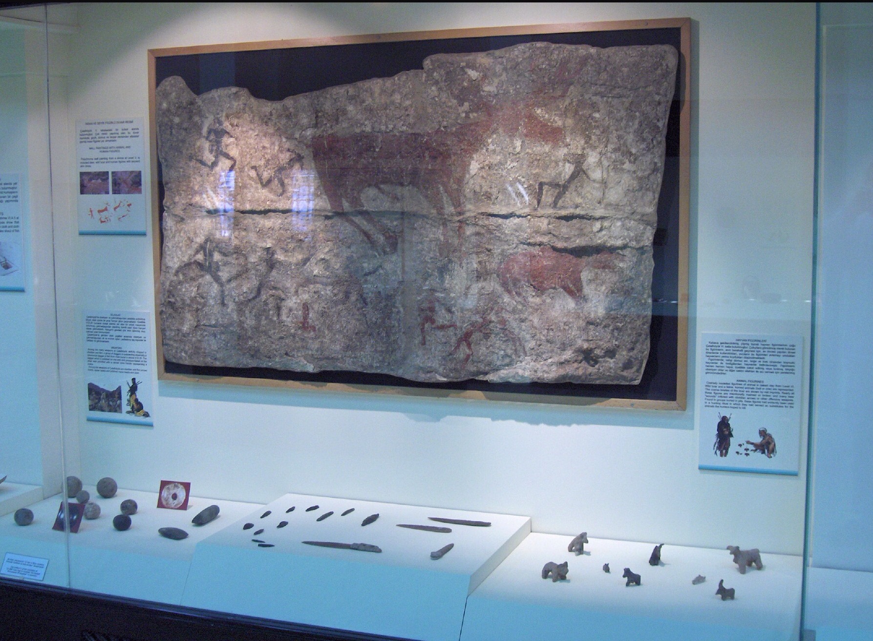
I have put together what, to me, and surely any other curious person, is the fascinating current understanding of the ancient people who made their way to Australia, possible 40 to 70,000 years ago. Those humans knew how to light fires, and in so doing it is thought they may have burned the landscapes they found which eradicated the habitat of many indigenous creatures. In turn species died out due to fires and maybe over hunting. Plants evolved in Australia which could withstand fire.

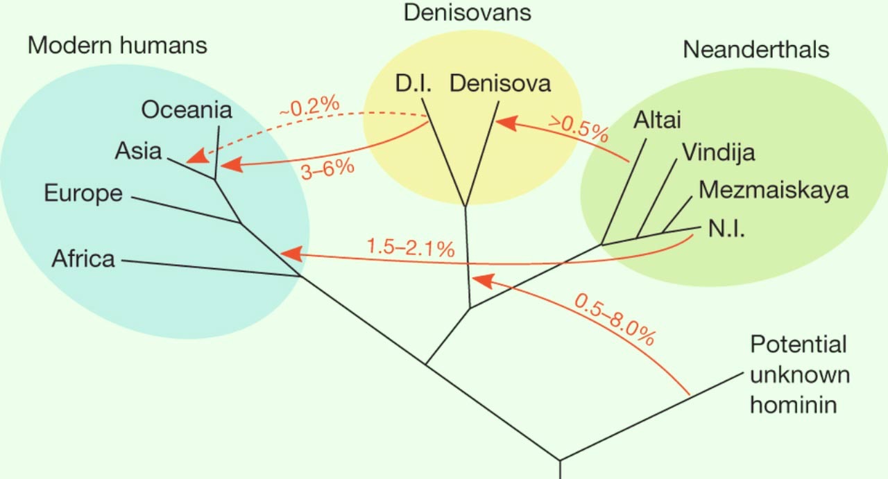
The genomes of Australian aborigines, New Guineans and some Pacific Islanders are about 6 percent Denisovan genes, according to earlier studies.  

All human beings have two genomes. The first is the genome of the DNA in chromosomes, the genome of the famous year 2000 human genome project. (See https://www.genome.gov/12011238/an-overview-of-the-human-genome-project/). The website states “The HGP has revealed that there are probably about 20,500 human genes. The completed human sequence can now identify their locations. This ultimate product of the HGP has given the world a resource of detailed information about the structure, organization and function of the complete set of human genes. This information can be thought of as the basic set of inheritable “instructions” for the development and function of a human being.”

The second and much smaller genome is of the DNA in mitochondria; it was mapped, to little public notice, in 1981. Mitochondria are minute, bean-shaped objects, hundreds of which bob about like so much flotsam in the warm, salty envelope of the cell. The body’s chemical plants, they gulp in oxygen and release the energy-rich molecules that power life. It is the mitochondrial DNA (mtDNA) which spans about 16,500 DNA building blocks (base pairs), representing a small fraction of the total DNA in cells. Mitochondria are widely believed to descend from bacteria that long ago somehow became incorporated into one of our evolutionary ancestors. They replicate themselves independently of the rest of the cell, without using its DNA. To accomplish this, they have their own genome, a tiny thing with fewer than fifty genes, left over from their former existence as free-floating bacteria. Because sperm cells are basically devoid of mitochondria, almost all of an embryo’s mitochondria come from the egg. Children’s mitochondria are thus in essence identical to their mother’s. More than that, every woman’s mitochondrial DNA is identical not only to her mother’s mitochondrial DNA, but to that of her mother’s mother’s mitochondrial DNA, and her mother’s mother’s mother’s mitochondrial DNA, and so on down the line for many generations. The same is not true for men. Because fathers don’t contribute mitochondrial DNA to the embryo, the succession occurs only through the female line. In the late 1970s several scientists realized that an ethnic group’s mitochondrial DNA could provide clues to its ancestry. Their reasoning was complex in detail, but simple in principle. People with similar mitochondria have, in the jargon, the same “haplogroup.” If two ethnic groups share the same haplogroup, it is molecular proof that the two groups are related; their members belong to the same female line.

The genome project has influenced all other studies of human existence, such that earlier archaeological finds can be reassessed if sufficient DNA can be retrieved. Frozen bodies previously trapped in the now thawing Arctic are in better condition for such analysis, but if there is sufficiently preserved DNA in ancient skeletal remains, astonishing leaps in tracing our ancient ancestors have been made.

Research, conducted by a large group of genetic scientists, shows that Neanderthals and Denisovans (See mapping of links below) are very closely related, and that their common ancestor split off from the ancestors of modern humans about 400,000 years ago.


Our human species is an African one: Africa is where we first evolved, and where we have spent the majority of our time on Earth. The place of our origin should surely be treated with immense respect.

Evidence is now suggesting that present-day Aboriginal Australians are the oldest population of humans living outside of Africa.


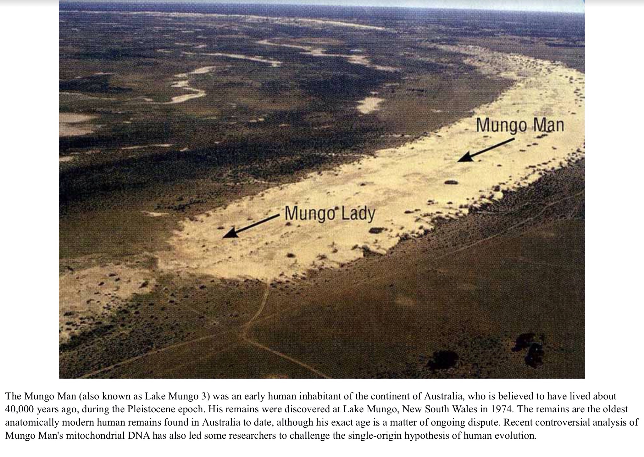
The Mungo Man was discovered by ANU archaeologist Dr. Jim Bowler on February 26, 1974 when shifting sand dunes exposed his remains. He was found near Lake Mungo, one of several dry lakes in the World Heritage listed Willandra Lakes Region. The body was sprinkled with red ochre, in what is the earliest incidence of such a sophisticated and artistic burial practice. This aspect of the discovery has been particularly significant to Indigenous Australians, since it indicates that certain cultural traditions have existed on the Australian continent for much longer than previously thought.

In 2003, a group of scientists from several Australian universities, led by the University of Melbourne, reached a new consensus that Mungo Man is about 40,000 years old. This age largely corresponds with stratigraphic evidence, and used four different dating methods, and brought together scientists from several different universities. The age of 40,000 years is currently the most widely accepted age for the Mungo Man and makes it the second oldest anatomically modern human remains found outside of Africa to date. The study also found that Mungo Lady was a similar age to Mungo Man, and not 30,000 years old, as previously thought. This made Mungo Lady the oldest cremated human remains yet discovered.


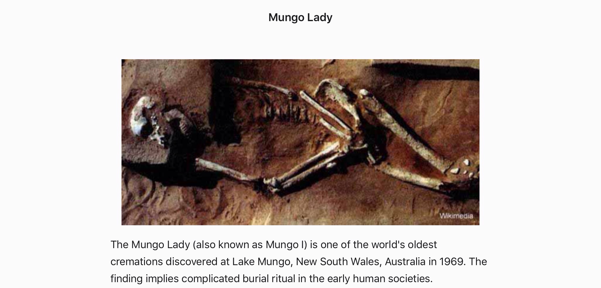
The pattern of burn marks on the bones of Mungo Lady implies an unusual ritual that after she died, the corpse was burned, smashed, then burned a second time. It was suspected that her descendants had tried to ensure that she did not return to haunt them.


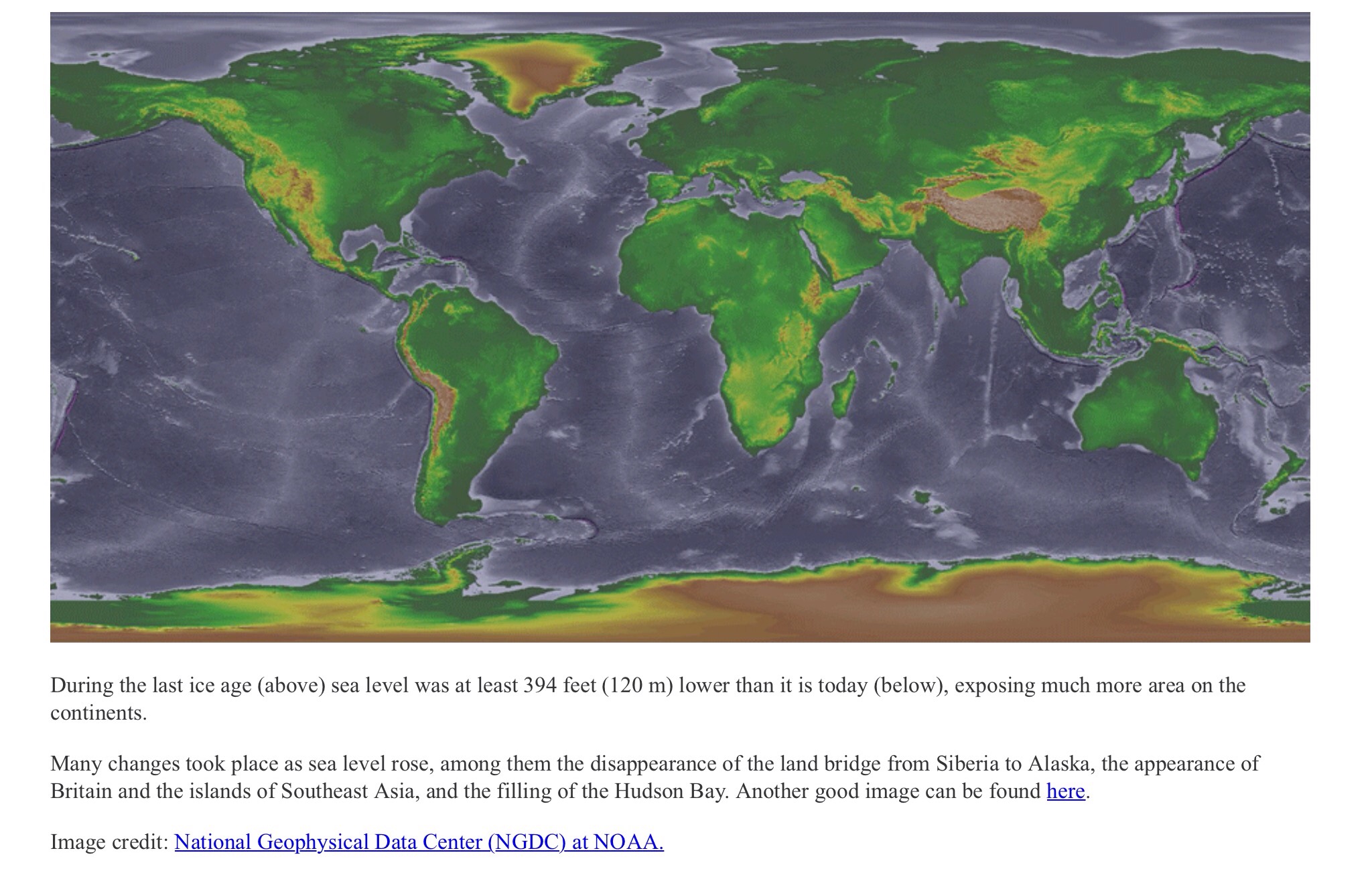
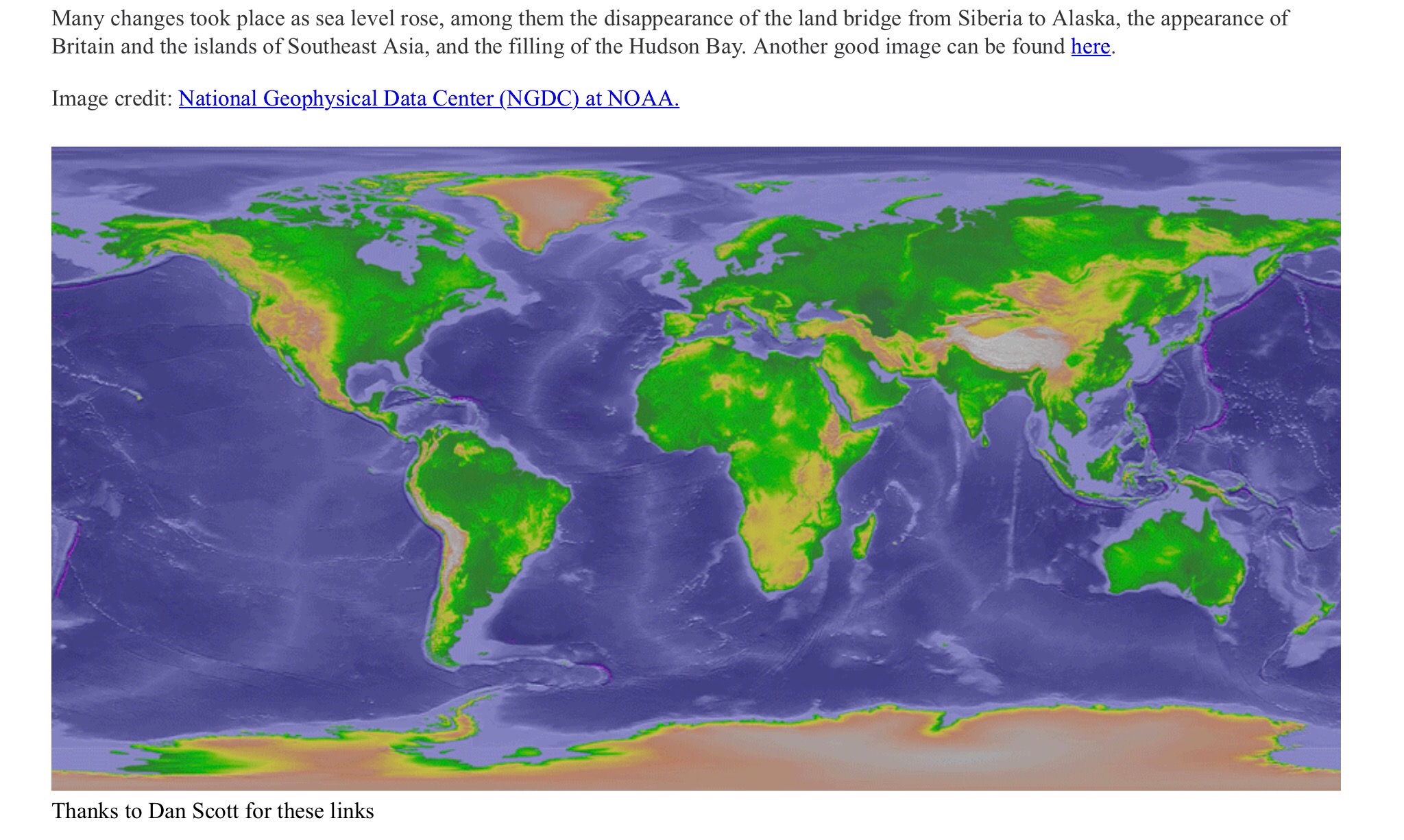
Aborigines are believed to be among the earliest human migrations out of Africa. This happened around 30 to 40,000 years ago. They possibly used the landmass which formed part of the Sahul continent, connected to the island of New Guinea via a land bridge. It is also possible that people came by island hopping via an island chain between Sulawesi and New Guinea and the other reaches North Western Australia via Timor.

It has now been discovered that 42,000 years ago  the earliest evidence of advanced deep sea fishing technology has been located at the Jerimalai cave site in East Timor.  Thisdemonstrates high-level maritime skills and by implication the technology needed to make ocean crossings to reach Australia and other islands, as these ancient humans were catching and consuming large numbers of big deep sea fish such as tuna.

Humans reached Tasmania approximately 40,000 years ago by migrating across a land bridge from the mainland that existed during the last ice age. After the seas rose about 12,000 years ago and covered the land bridge, the inhabitants there were isolated from the mainland until the arrival of European settlers.

See https://genographic.nationalgeographic.com/human-journey/

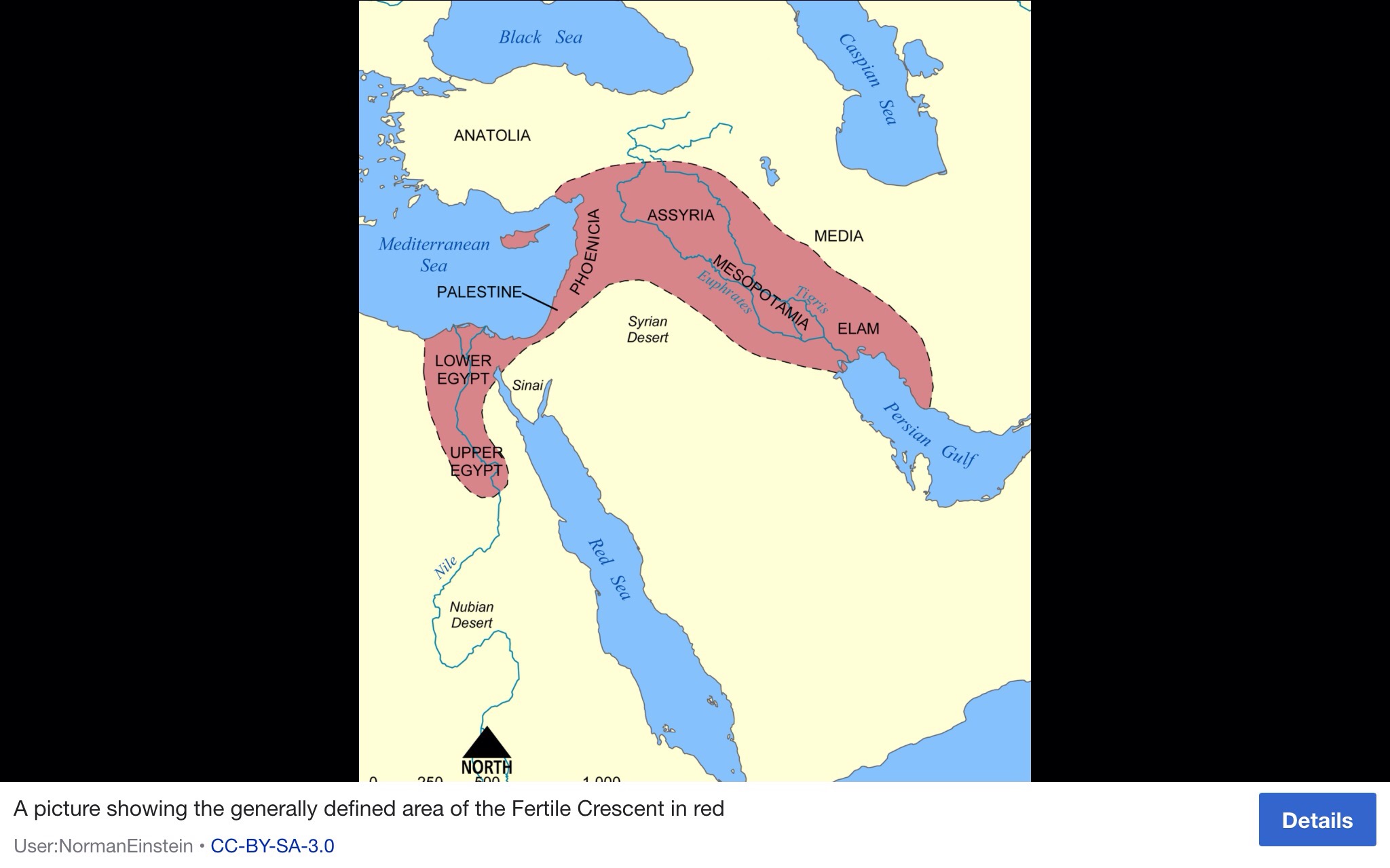
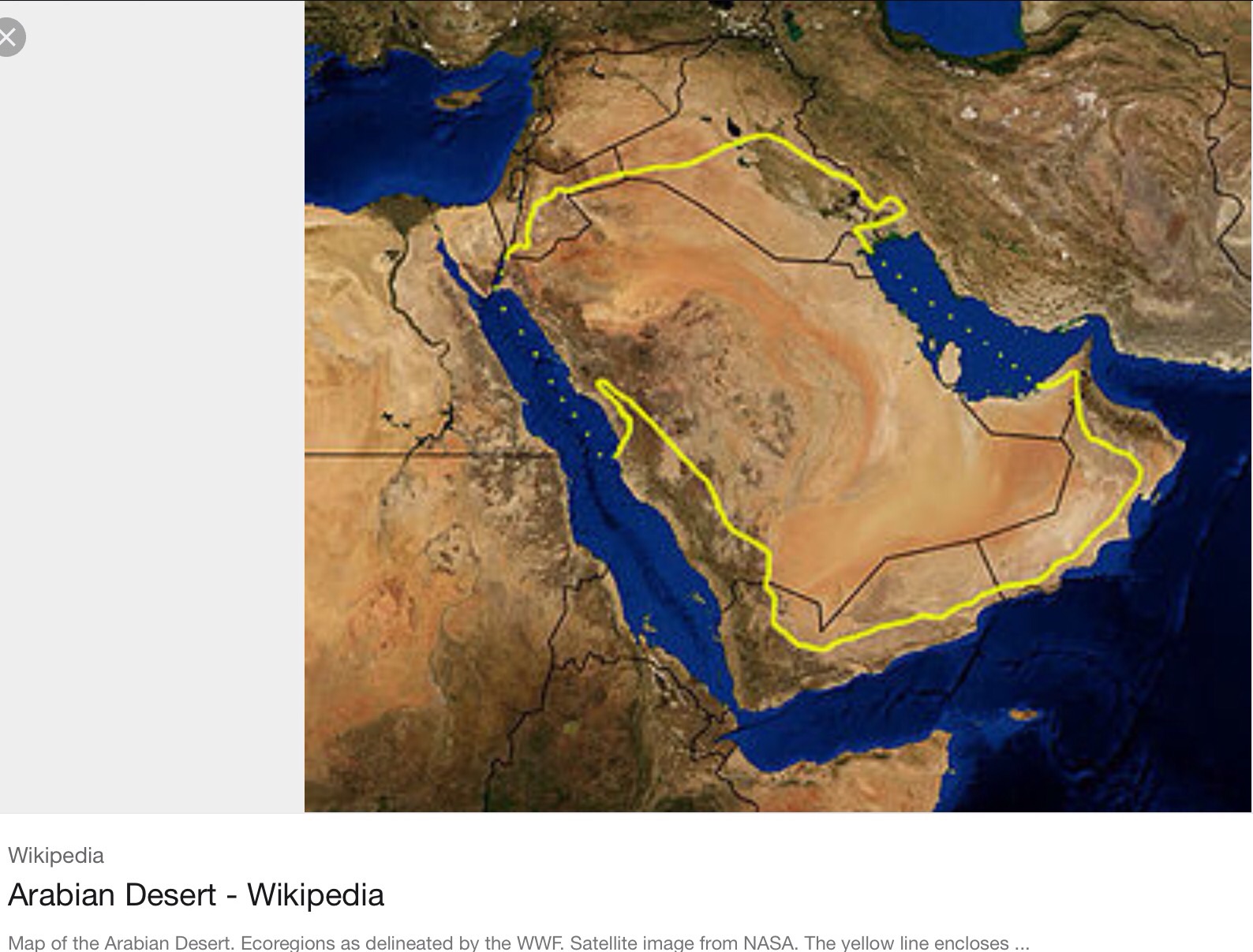
Once the climate started to improve, after 70,000 years ago, we came back from this near-extinction event. The population expanded, and some intrepid explorers ventured beyond Africa. The earliest people to colonize the Eurasian landmass likely did so across the Bab-al-Mandab Strait separating present-day Yemen from Djibouti. These early beachcombers expanded rapidly along the coast to India, and reached Southeast Asia and Australia by 50,000 years ago. The first great foray of our species beyond Africa had led us all the way across the globe.

In August 2012, scientists reported the discovery of human skull fragments in a limestone cave in northern Laos that date back to between 46,000 and 63,000 years ago. The finding was surprising, because it indicated early humans roamed far and wide across Asia after leaving Africa, venturing north and northeast across rough mountainous terrain into Laos and perhaps even China, Vietnam, and Thailand.

Reaching Australia would have presented significant challenges for ancient humans. An ocean has always separated Asia and Oceania, and travel between the two continents would have required humans to navigate dozens of miles of open water. Whether humans colonized Australia intentionally or by accident—after being blown there by monsoon winds, for example—is unknown, although National Geographic’s Wells thinks the former scenario is more likely.

Spencer Wells, a geneticist and a National Geographic explorer-in-residence, has speculated that the first Australians landed in northern Australia and Papua New Guinea—then part of the same landmass—and gradually moved inland by following the river systems of Queensland and southern Australia.

In 2011, using modern gene sequencing techniques, researchers sampled the DNA from a lock of hair that a young Aboriginal man had donated to a British anthropologist in 1923. When DNA in the hair was compared with the genomes of people living in Asia, Europe, and Africa, scientists discovered that Aboriginal Australians are more closely related to Africans than they are to modern Asians and Europeans.

This suggests humans migrated into Eastern Asia in multiple waves and that today’s Aboriginal Australians are descended from an early wave that left Africa about 70,000 years ago, before the ancestors of Asians and Europeans. If confirmed, the finding means that present-day Aboriginal Australians are the oldest population of humans living outside of Africa.

Colonial period

The first Scottish settlers arrived in Australia with the First Fleet in 1788, including three of the first six Governors of New South Wales John Hunter, Lachlan Macquarie (often referred to as the father of Australia) and Thomas Brisbane. … They were not all Scots, but had been tried in Scotland. The First Fleet is the name given to the first group of eleven ships that carried convicts from England to Australia in 1788. Beginning in 1787 the ships departed with about 778 convicts (586 men, 192 women), provisions and agricultural implements. Seventeen convicts died and two were pardoned before departure.

This was just 7 years after the first British expedition of the Endeavour under command of Lieutenant James Cook who was himself the son of a Scottish ploughman. Cook navigated and charted the east coast of Australia, making first landfall at Botany Bay on 29 April 1770. His reports in Cook’s expedition would lead to British settlement of the continent, and during the voyage Cook also named two groups of Pacific islands in honour of Scotland: New Caledonia and the New Hebrides. The first European to die on Australian soil was a Scot; Forbey Sutherland from Orkney, an able seaman died on 30 April 1770 of consumption and was the first to be buried on the colony by Captain Cook, who named Sutherland Point at Botany Bay in his honour.

Now more humans want to migrate to Australia. Many are rejected.

The original peoples of Australia are being seemingly tricked into surrendering their homelands forever with Indigenous Land Use Agreements (ILUAs) “without understanding they are whitewashing their own history, under the invaders’ law.

This surrendering trick takes effect before the deed of grant of land is issued to the shires of the whole area. In this way compensation is also avoided.”

This opens up their land to corporates who seek to exploit the coal deposits for example, or any other profitable activity which would not be shared with the indigenous people and would sabotage their cherished lands.

see 

http://nationalunitygovernment.org/content/indigenous-land-use-agreements-iluas-trick-first-peoples-surrendering-their-homelands

Posted in anthropocene | Tagged , , , , , , , , , | 1 Comment

Destruction of the Garden

Humans thrive when nature provides them with fertile land where they feel safe and can develop skills. This was such a place, between less abundant and often hostile lands, it was a place humans would target and fight to keep and, in the end, as populations became more demanding, destroy by overuse. This was the Fertile Crescent.

The Fertile Crescent is traditionally associated (in Jewish, Christian and Muslim faiths) with the earthly location of the Garden of Eden.

Map of showing location of Fertile Crescent


In 1916, the name was coined by Egyptologist James Henry Breasted in his work Ancient Times: A History of the Early World, where he wrote, “This fertile crescent is approximately a semi-circle, with the open side toward the south, having the west end at the south-east corner of the Mediterranean, the centre directly north of Arabia, and the east end at the north end of the Persian Gulf.” 

When populations were small and took up little space in the Fertile Crescent, in around 10000 BC (12,000 years ago), farming practices began to develop and humans began to settle rather than be nomads. 

Humans had always gathered seeds and berries as hunter-gatherers. Now they sowed the seeds and reaped the crop. For human history this was the Neolithic revolution. Until that time, humans had no sense of property, no concept of protecting an area of land they believed to belong to them alone, no thought of the costly defence of such territory and all the artefacts they were to create and identify as their own.

They just wanted to be comfortable and have plentiful food and water ‘on hand’, so to speak.

Over thousands of years, these early farmers domesticated the first crops and transformed sheep, wild boars and other creatures into domestic animals.

Recently (2016) population geneticists at Harvard Medical School in Boston, Massachusetts, Losif Lazaridis and David Reich, managed to take a genetic sample from a tiny ear bone called the petrous, to analyse the genomes of the 44 Middle Eastern individuals, who lived between 14,000 and 3,500 years ago. As it has been so far hugely difficult to analyse DNA in hotter climes, this has proven to be a breakthrough. 

Their findings, and more recent studies, suggest the ‘toolkit’ for farming came from two Middle Eastern populations who independently developed farming and then spread the technology to Europe, Africa and Asia.

The team found stark differences between the genomes of Neolithic individuals from the southern Levant region, including Israel and Jordan, and those living across the Zagros Mountains in western Iran. The Zagros early farmers were instead more closely related to nearby hunter-gatherers who lived in the region before the Neolithic.

This pattern of ancestry adds to the evidence that the hunter-gatherers in the southern Levant and Iran independently developed farming, says Roger Matthews, an archaeologist at the University of Reading, UK, who co-directs the Central Zagros Archaeological Project in Iran.

The Zagros farmers domesticated goats as well as cereals such as emmer, whereas their counterparts to the west had their own crops, including barley and wheat. Around 9,500 years ago, these traditions began spreading around the Middle East, Rogers says, noting that the two populations of farmers may have mixed in eastern Turkey while seeking out sources of obsidian, which was useful for making tools. By the time farmers in present-day Turkey began migrating to Europe, they carried a ‘Neolithic toolkit’ that included crops, animals and tools from both farming traditions.

But the present day state of the Fertile Crescent speaks of the tragedy of Anthropocene impact.

Around 90 per cent of the Mesopotamian marshlands have been lost, mainly as a result of drainage and damming.

A study by scientists in 2001 at the United Nations Environment Programme (UNEP), drawing on historical and satellite images, has collected the first hard evidence detailing the true extent of damage to this important habitat for people, (Marsh Arabs) wildlife and fisheries.

Image of Marsh Arab


The immediate cause of loss of marshland is, however, the massive drainage works implemented in southern Iraq in the early 1990s following the second Gulf War.

The satellite images provide hard evidence that the once extensive marshlands have dried-up and become desert with vast stretches salt encrusted. A small northern fringe of the Hawizeh (known as the Hawr Al-Azim in Iran), is all that remains. The Hawizeh Marshes are a complex of marshes that straddle the Iraq and Iran border. The marshes are fed by two branches of the Tigris River (the Al-Musharrah and Al-Kahla) in Iraq and Karkheh River in Iran. The Hawizeh marsh is critical to the survival of the Central and Hammar marshes, which also make up the Mesopotamian Marshes, because they are a refuge for species that may recolonize or reproduce in the other marshlands. The Hawizeh Marshes are drained by the Al-Kassarah. This river plays a critical role in maintaining the marshes as a flow-through system and preventing it from becoming a closed saline basin.

Even this last vestige is rapidly disappearing as its water supply is impounded by new dams and diverted for irrigation. The collapse of Marsh Arab society, a distinct indigenous people that has inhabited the marshlands for millennia, adds a human dimension to this environmental disaster.

Around one fifth of the estimated half-million Marsh Arabs are now living in refugee camps in Iran with the rest internally displaced within Iraq. A 5,000 year-old culture, heir to the ancient Sumerians and Babylonians, is seriously in jeopardy of coming to an abrupt end.

The impact of marshland loss on the area’s teeming wildlife is probably equally devastating with significant implications for global biodiversity, including migratory birds, from Siberia to southern Africa. The marshlands disappearance has placed an estimated forty species of waterfowl at risk. Mammals, such as the smooth coated otter, that exist only in the marshlands are now considered extinct. Coastal fisheries in the northern Gulf, which depend on the marshlands for spawning grounds, have also experienced a sharp decline.

The Marsh Arabs are believed to be the cultural descendants of the ancient Sumerian and later Babylonian civilizations.

Sumer was the southernmost region of ancient Mesopotamia (modern-day Iraq and Kuwait) which is generally considered the cradle of civilization. The name comes from Akkadian, the language of the north of Mesopotamia, and means “land of the civilized kings”. The Sumerians called themselves “the black headed people” and their land, in cuneiform script, was simply “the land” or “the land of the black headed people”. In the biblical Book of Genesis Sumer is known as Shinar. One of the many ‘taken for granted’ gift to us from them is the 24 hour clock. Their empire was built from the Middle to Late Bronze Age. The city-states of Sumer during this time fought for control of arable land and water rights until the rise of the First Dynasty of Lagash in 2500 BCE. 

Image of Marsh Arab homeland


The same communal mudhif buildings seen in marsh culture today have also been seen depicted on Sumerian seals from 5000 years ago. There are also apparent similarities between the agricultural and irrigation practices of the ancient Sumerians and the modern day ‘Ma’dan’, as the present Marsh Arabs are known. The Sumerians also travelled in similar slender reed boats, caught fish and birds with long spears, lived on marsh islands in reed houses, and herded water buffalo, sheep and cattle.

Yet another indigenous group forced from their ancient way. Watch more recent film of the Marsh Arabs at https://youtu.be/Awsjn-_rvxI

Posted in anthropocene | Tagged , , , , , , , , , , | 2 Comments

Movement of People of the African Sahara

I have been particularly interested in finding out why people migrated out of Africa, but there is also the story of those who remained.  The adaptable indigenous human, always so ingenious in the most hostile environments. Yet becoming part of the landscape and working with it, not against it.

Of interest: the word Sahara means desert in Arabic.

The world’s largest hot desert, the Sahara, is a subtropical desert in northern Africa. 


The Sahara’s topographical features, (according to “The Living Africa,” by Steve Bloom, 2008) :

include not only the iconic sand dune fields, but also arid mountains, plateaus, sand- and gravel-covered plains, shallow basins and large oasis depressions. Its highest point is Chad’s Mount Koussi (an extinct volcanic crater that rises 11,204 feet above sea level at the peak), and its lowest, Egypt’s Qattera Depression (an oasis depression that lies 436 feet below sea level at the deepest point)

 In 2007, Iain Stewart and joint author John Lynch wrote in their book Earth: the power of the planet, 2007, about a series of events which created the Sahara desertification:

 “A small change in the distribution of incoming solar radiation, due to a subtle change in the Earth’s orbit, had weakened the equatorial storms that fed the African monsoons. Within a few decades, the tropical summer rains that once watered much of Northern Africa had retreated south, and vast areas of woodland and marsh had become parched wastelands. Over the following centuries, the drifting sands of the desert spread north as well, and the ancient peoples who had farmed the once fertile Sahara heartland were pushed out. Part of the exodus moved east to settle a river valley that had previously been too marshy, and so began the Nile civilisation and the age of the pharaohs. Others remained in isolated havens where water was still available, but by 2000 years ago only one group of hardy people was left holding back the desert: the Garmanthians, skilled charioteers who held in check the southward advances of imperial Rome. But on their flank, the advance ofthe desert was unstoppable. By AD 500, the Garmanthian culture was gone, its people scattered to a nomadic existence and its ruins buried beneath the sand.”

Current research using “a series of climate simulations, co-led by Dr Camille Contoux of the Bjerknes Center for Climate Research in Bergen, Norway, suggests that the desertification of Sahara started about 7 million years ago, at least four million years earlier than previously thought………this is due “to a recent discovery of 7-million-year-old sand dune deposits in the northern Chad Basin.”

Map to locate Chad:


The researchers describe the Sahara desert as:

At over 9,400,000 km2, it covers nearly 10 percent of the African continent, including Algeria, Chad, Egypt, Libya, Mali, Mauritania, Morocco, Niger, Sudan and Tunisia.”

Robert Korty, associate professor in the Department of Atmospheric Sciences, along with colleague William Boos of Yale University, have had their work published in the current issue of Nature Geoscience in 2016. They are working on the effect of the Hadley circulation rainfall pattern. (The Hadley cell, named after George Hadley, is a global scale tropical atmospheric circulation that features air rising near the equator, flowing poleward at 10–15 kilometers above the surface, descending in the subtropics, and then returning equatorward near the surface.)

Hadley Circluation model:


Korty tells us “As little as 6,000 years ago, the vast Sahara Desert was covered in grassland that received plenty of rainfall, but shifts in the world’s weather patterns abruptly transformed the vegetated region into some of the driest land on Earth.” He and his team are using computer models and other data, and have found links to rainfall patterns thousands of years ago.

The mystery was why did the tropical rainfalls move so far north? 

“The Hadley circulation is a tropical atmospheric circulation that rises near the equator. It is linked to the subtropical trade winds, tropical rainbelts, and affects the position of severe storms, hurricanes, and the jet stream. Where it descends in the subtropics, it can create desert-like conditions. The majority of Earth’s arid regions are located in areas beneath the descending parts of the Hadley circulation.

“We know that 6,000 years ago, what is now the Sahara Desert was a rainy place,” Korty adds.

Korty says. “We were able to conclude that the variations in Earth’s orbit that shifted rainfall north in Africa 6,000 years ago were by themselves insufficient to sustain the amount of rain that geologic evidence shows fell over what is now the Sahara Desert. Feedbacks between the shifts in rain and the vegetation that could exist with it are needed to get heavy rains into the Sahara.”

Simulating paleoclimates in the Sahara region, a team of researchers from Germany and United Kingdom has found evidence of three major river systems that likely existed in North Africa about 130,000 – 100,000 years ago, but are now largely buried by dune systems in the desert.

Image they provided:


This image shows Irharhar, Sahabi and Kufrah rivers systems in the Sahara region. The green points show the location of archaeological sites in the region. Image credit: Coulthard TJ et al.

It’s exciting to think that 100,000 years ago there were three huge rivers forcing their way across a 1,000 km of the Sahara desert to the Mediterranean and that our ancestors could have walked alongside them,” said Dr Tom Coulthard of the University of Hull, UK, who is a lead author of the study published in the journal PLoS ONE.A

Previous studies have shown that people traveled across the Saharan mountains toward more fertile Mediterranean regions, but when, where and how they did so is a subject of debate.

Existing evidence supports the possibilities of a single trans-Saharan migration, many migrations along one route, or multiple migrations along several different routes.

The existence of ‘green corridors’ that provided water and food resources were likely critical to these events, but their location and the amount of water they carried is not known.”

It is worth reading the explanation of how aquifers beneath the Sahara hold water which has lain there since the precipitation of the last glacial age. See http://www.oxfordpresents.com/ms/nance/water-in-the-sahara-desert/

Map of Arabian Desert


Adjacent is the Arabian desert, located in Western Asia. It is a vast desert wilderness stretching from Yemen to the Persian Gulf and Oman to Jordan and Iraq. It occupies most of the Arabian Peninsula, with an area of 2,330,000 square kilometers (900,000 sq mi). It is the fourth largest desert in the world, and the largest in Asia. At its center is the Rub’al-Khali, one of the largest continuous bodies of sand in the world. 

The Arabian Desert consists of two major regions. The first, the ancient Arabian platform (a segment of the African Shield), is in the west. It is composed mainly of Precambrian gneiss (dated to between 2.6 billion and roughly 541 million years ago) and was assembled roughly 900 to 541 million years ago.(Brittanica)

But back to the Sahara – a massive subject, only touched on here in my short blogs.

A little more useful detail at https://www.desertusa.com/du_sahara.html an extract here:

Its permanent rivers are the Nile and the Niger. The Nile rises in central Africa, south of the Sahara, and flows northward through Sudan and Egypt and empties into the Mediterranean. The Niger rises in western Africa, southwest of the Sahara, and flows northeastward into Mali and the desert then turns southeastward, through Nigeria, and empties into the Gulf of Guinea.

If you find yourself stuck in the desert, here are a few tips from http://www.pbs.org/lawrenceofarabia/revolt/water.htm

Lawrence of Arabia . Desert Survival . Water | PBS


Water

The ability to transport and find water is perhaps the most crucial element for survival in the desert. In extreme temperatures the human body can require over a gallon of water a day. 

Bedouins are nomadic people. They move on to fresh pastures when their grazing lands are exhausted. They cannot afford to to sit tight where water is not plentiful. 

Constantly on the move in a harsh environment they carefully planned their routes across desert landscapes, calculating precisely how far their water supply will stretch between wells. 

The goat-skin bag has long been the traditional method for carrying water and, once drawn from deep wells, experience dictates how severely water must be rationed. 

Tricks to finding water in the desert:

An old Bedouin trick is to turn over half-buried stones in the desert just before sun up. Their coolness causes dew to form on their surface.

Desert grass will also form dew in the pre-dawn with your tongue. It can be soaked up with a cloth and wrung out into a container.

Where sand dunes meet the sea digging above the high tide mark might reveal a thin layer of fresh water sitting atop a heavier layer of salt water.

Flies and mosquitos are a giveaway for a water source and bees fly in a straight line to and from water up to 1000 metres away.

Look out for pigeons and doves – they can only exist near fresh water

Water seepage in canyons, small pockets of water in sandstone rock formations and digging at the base of rocks and mountains can produce water

Even contaminated water has its uses. It can be used to soak your clothing and reduce water loss from perspiration.close 

The Taureg of Mauritania, NW Africa, an example of a people who still cling to their nomadic existence

And extracted from https://en.m.wikipedia.org/wiki/Tuareg_people:

The Tuareg today inhabit a vast area in the Sahara, stretching from far southwestern Libya to southern Algeria, Niger, Mali and Burkina Faso. Their combined population in these territories exceeds 2.5 million, with an estimated population in Niger of around 2 million (11% of inhabitants) and in Mali of another 0.5 million (3% of inhabitants. The Tuareg are also the majority ethnic group in the Kidal Region of northeastern Mali.

In antiquity, the Tuareg moved southward from the Tafilalt region into the Sahel under the Tuareg founding queen Tin Hinan, who is believed to have lived between the 4th and 5th century. The matriarch’s 1,500 year old monumental Tin Hinan tomb is located in the Sahara at Abalessa in the Hoggar Mountains of southern Algeria. Vestiges of an inscription in Tifinagh, the Tuareg’s traditional Libyco-Berber writing script, have been found on one of the ancient sepulchre’s walls.

Some studies have linked the Tuareg to early ancient Egyptian civilization.

Archaeological excavations of prehistoric tombs in the Maghreb have yielded skeletal remains that were painted with ochre. Although this ritual practice was known to the Iberomaurusians, the custom seems instead to have been primarily derived from the ensuing Capsian culture. Megalithic tombs, such as the jedar sepulchres, were also erected for religious and funerary purposes. In 1926, one such tomb was discovered south of Casablanca. The monument was engraved with funerary inscriptions in the ancient Libyco-Berber writing script known as Tifinagh, which the Tuareg still use. 

You might like to watch this this fascinating documentary to find out more about Taureg life: https://youtu.be/CUHEc1fQhwo

Posted in anthropocene | Tagged , , , , , , , , , , , , , , | Leave a comment

The connectivity of oceans and human survival

Business jargon uses SWOT analysis (Strengths, Weaknesses, Opportunities, Threats) to determine decision making. I would suggest this is probably how all humans have approached challenges of survival, but business jargon has encapsulated the process.

As the oceans warmed and the ice melted at the end of the last glacial age, around 11000 BC, humans saw climate change transforming their landscapes, sometimes for the better, often for the worst. If it was for the worst, humans had to think their way out of the problem. SWOT analysis was likely their chosen methodology.

At the height of the Ice Ages (and there were at least twenty!), sea levels were up to 300 ft lower than today. Just 8,000 years ago not only was much of the North Sea dry land, but so was the Irish Sea and the English Channel. In between these glaciations, the ice would melt and sea levels rise. Freed from the weight of ice, northern Britain began to rise while southern Britain began to sink – a process that continues today as the land tilt steepens. Long, dry raised beaches can be seen in Scotland, while more and more land is lost to the sea in the south and in the east. We make much of rising sea levels and global warming today, but consider the effects of massive amounts of water being released into the sea as the ice caps (covering much of the Northern Hemisphere) melted. Sea levels rose not by a foot or two, but by hundreds of feet.

The Intergovernmental Panel on Climate Change (IPCC) has stated:

The two major causes of global sea level rise are thermal expansion of the oceans (water expands as it warms) and the loss of land-based ice due to increased melting…

 Global sea level rose by about 120 m during the several millennia that followed the end of the last ice age (approximately 21,000 years ago), and stabilised between 3,000 and 2,000 years ago. Sea level indicators suggest that global sea level did not change significantly from then until the late 19th century. The instrumental record of modern sea level change shows evidence for onset of sea level rise during the 19th century. Estimates for the 20th century show that global average sea level rose at a rate of about 1.7 mm yr–1.”

Images 

Earth when sea levels were 120m lower than today.(See https://www.iceagenow.com/Sea_Level_During_Last_Ice_Age.htm)


When humans were faced with more water and less land, they built watercraft, a high level innovation. But now we know they didn’t just learn to sail around 3000 BC. No. Recent findings of amazing voyages have been discovered and dated as happening up to 130, 000 years ago!

Michael Morwood, an archaeologist at the University of New England in Armidale, Australia, has long proposed that Homo erectus voyaged from the Indonesian island of Bali to nearby Flores, where excavations have revealed 700,000- to 800,000-year-old stone tools. Models for the early hominin dispersal out of Africa received considerable attention when the joint Australian-Indonesian research team headed by Morwood discovered Homo floresiensis in the Liang Bua cave on the island of Flores, Indonesia (Morwood & Oosterzee 2007). The finding of Homo floriensis, released on 28 October 2004, has implications for the dispersal of hominin and human dispersal out of Africa, and the colonisation of Asia. It has attracted substantial debate from, in part, supporters of the multi-regionalist theory of Homo sapiens evolution (Morwood). The continued study of Homo floriensis has taken a multidisciplinary approach including palaeanthropological, morphological (see Kaif et al. 2011), and pathological analysis combined with dentition study, ancient DNA extraction and tomographical techniques. Of additional interest to the find are the lithic tools associated with the discovery of Homo floriensis and the cognitive behaviours connected with their manufacture and use (Brumm et al. 2006). Recent research estimates the faunal sequence and minimum age for hominins on Flores at 1.1million years ago, ensuring the study covers the entire period of hominin habitation in the region. Excavations at Mata Menge, Flores, hope to provide greater evidence on the early hominin colonisation of the Indonesian area. The public interest in these hominin finds have sparked numerous documentaries and written works detailing all manner of scientific investigation and discussion on the subject.

Some 130,000 years ago, scientists say, a mysterious group of ancient people visited the coastline of what is now Southern California. More than 100,000 years before they were supposed to have arrived in the Americas, these unknown people used five heavy stones to break the bones of a mastodon. They cracked open femurs to suck out the marrow and, using the rocks as hammers, scored deep notches in the bone. When finished, they abandoned the materials in the soft, fine soil; one tusk planted upright in the ground like a single flag in the archaeological record. Then the people vanished. Perhaps there was a sudden jump in sea levels which cut them off from their watercraft. We can’t know how the previous ice age melts behaved, but we do know from the last Ice Age, as researchers from Southampton tell us, that sea-level rose by an estimated average of about 1 metre per century, interrupted by rapid ‘jumps’ during which it rose by up to 2.5 metres per century. The findings were published in Global and Planetary Change.

Sea levels began to stabilise by around 3000 BC. It is now evident from archaeological finds that Ancient Egyptians knew how to assemble wooden planks into a hull. They used woven straps to lash the planks together, and reeds or grass stuffed between the planks helped to seal the seams. The Greek historian and geographer Agatharchides had documented ship-faring among the early Egyptians: “During the prosperous period of the Old Kingdom, between the 30th and 25th centuries B. C., the river-routes were kept in order, and Egyptian ships sailed the Red Sea as far as the myrrh-country.” Sneferu’s ancient cedar wood ship Praise of the Two Lands is the first reference recorded (2613 BC) to a ship being referred to by name.

The ancient Egyptians were perfectly at ease building sailboats. A remarkable example of their shipbuilding skills was the Khufu ship, a vessel 143 feet (44 m) in length entombed at the foot of the Great Pyramid of Giza around 2500 BC and found intact in 1954.

Khufu’s ship is one of the oldest, largest, and best-preserved vessels from antiquity. It measures 43.6 m (143 ft) long and 5.9 m (19.5 ft) wide.

It was thus identified as the world’s oldest intact ship and has been described as “a masterpiece of woodcraft” that could sail today if put into water, lake and river. However, the vessel may not have been designed for sailing (no rigging) or paddling (no room).

The ship was one of two rediscovered in 1954 by Kamal el-Mallakh – undisturbed since it was sealed into a pit carved out of the Giza bedrock. It was built largely of Lebanon cedar planking in the “shell-first” construction technique, using unpegged tenons of Christ’s thorn. The ship was built with a flat bottom composed of several planks, but no actual keel, with the planks and frames lashed together with Halfah grass, and has been reconstructed from 1,224 pieces which had been laid in a logical, disassembled order in the pit beside the pyramid.

Image of reconstructed ship


Power was centred on the Mycenaean armies, donning their magnificent Bronze armour, and utilising their finely crafted weapons. They shared several common features with other significant Late Bronze Age powers: they were initially based on heavy infantry, which bore spears, large shields and, in some occasions, armor. Later in the 13th century BC, Mycenaean warfare underwent major changes both in tactics and weaponry. Armed units became more uniform and flexible, while weapons became smaller and lighter. The spear remained the main weapon among Mycenaean warriors until the collapse of the Bronze Age, while the sword played a secondary role in combat. The process of making their quality bronze products required traders like the seafaring Phoenecians.

The Phoenecians were the people who sailed to far off lands from the Mediterranean, to find rare materials. These people were vital to the power base of the hierarchical Bronze Age Mycenaean empire which existed toward the final era of the Bronze Age. The Mesopotamian Bronze Age began about 3500 BC and ended with the Kassite period (c. 1500BC – c. 1155 BC). The making of bronze armour and weaponry required Copper-tin ores which were only found in far flung places that only sailors like the Phoenicians dared to explore. There were no tin bronzes in Western Asia before trading in bronze began in the 3rd millennium BC. The bronze age collapse occurred about 1200 BC after flourishing since 3000 BC, a period of 1800 years.

The important bronze age civilizations were centered in the area from modern-day Turkey, Iran, Iraq all the way south to Egypt. To make bronze required the casseritite. The name derives from the Greek kassiteros for “tin”; or from the Phoenician word Cassiterid referring to the islands of Ireland and Britain, the ancient sources of tin; or, as Roman Ghirshman (1954) suggests, from the region of the Kassites, an ancient people in west and central Iran.

The Phoenicians were master sailors, traders and craftsmen who established a great commercial network from their homeland on the coastal areas of the modern day Syrian and Lebanese coast from their great trading cities of Tyre, Sidon, Byblos, Acco and Berytus (Beirut) . Their commercial empire extended throughout the ancient Mediterranean world and they established colonies in Cyprus, Sardinia. Sicily, Malta, North Africa, Tripolis (Libya), Ikossim (Algiers), Spain, Gadir (Cadiz), Malaca (Malaga) and Ibossim (Ibiza). Phoenician sailors braved the seas beyond the Pillar of Hercules to sail as far as the modern day Azores, Senegal and Ireland . 

According to the Greek historian Herodotus, a Phoenician fleet was commissioned to circumnavigate Africa by Pharaoh Necho (610-595 B.C.), however, there is no Egyptian evidence for this feat . However, there is historical evidence that Hanno the Navigator (c. 500 B.C.) did sail as far south as modern day Senegal with a large fleet . 

Tracking languages, a 2009 Bayesian analysis identified an origin for Semitic languages in the Levant around 3750 BC with a later single introduction of Ge’ez from what is now South Arabia into the Horn of Africa around 800 BC, with a slightly earlier introduction into parts of North Africa and southern Spain with the founding of Phoenician colonies such as ancient Carthage in the ninth century BC and Cádiz in the tenth century BC. The earliest records of Semitic languages are from 30th century BCE Mesopotamia.

To maintain the Phoenicians commercial empire, they built hundreds of colonies, some of which became great cities themselves, such as Carthage, which became powerful enough to challenge Rome itself . 

They developed a more efficient writing system, the alphabet, which spread throughout the Mediterranean with their trade. The Phoenician alphabet developed from the North Emetic alphabet and was in use as early as the 11th cent B.C. and is the ancestor of Arabic, Latin, Hebrew and Greek scripts and the script to write this very article . Phoenician and Punic (Carthaginian Phoenician was in use until the first cent B.C. in Phoenicia and the third cent A.D. in North Africa . St. Augustine was the last ancient writer with knowledge of Punic.

During the sixteenth century B.C. the Phoenicians were made subject to Egypt and remained under Egyptian rule for over four centuries.

After 1200 B.C., they enjoyed a period of independence, the Phoenician golden age of sea commerce and culture from 1200 to 800 B.C. Phoenician traders have been credited with the rebirth of the Mediterranean economy and culture after the Late Bronze Age ( c. 1550 B.C.) collapse of the Hittites and Mycenaens in the 1200s B.C. and helped bring Greece out of the isolation of the so called Greek Dark Ages of 1200~800 B.C.


A rare genome has been identified in an ancient body pulled from a sarcophagus on a site near ancient Carthage, in a discovery which could throw new light on the history of human movement.

The DNA of the 2,500-year-old remains of the ‘Young Man of Byrsa’ , discovered in 1994 and believed to be that of a young male Phoenician, was sequenced by a team of scientists.

They found it contained an extremely rare type of genome sequence, known as U5b2c1, which is almost unknown among modern populations. The research has now been published in the scientific journal Plos One. 

“This is first example of an ancient Phoenician genome,” Professor Lisa Matisoo-Smith, co-leader of the study with Dr Pierre Zalloua, told The Independent. The DNA was found on the site of Byrsa, a citadel close to the ancient city of Carthage, which now just outside Tunis, Tunisia.

The collapse of the power bases of the Bronze Age empires was caused by an unexpected and powerful attack of the Sea Peoples. The nationality of the Sea Peoples remains a mystery as the existing records of their activities are mainly Egyptian sources who only describe them in terms of battle such as the record from the Stele at Tanis which reads, in part, “They came from the sea in their war ships and none could stand against them.” This description is typical of Egyptian references to these mysterious invaders. 

See http://www.ancient.eu/uploads/images/4545.png?v=1485681717


This famous scene from the north wall of Medinet Habu is often used to illustrate the Egyptian campaign against the Sea Peoples in what has come to be known as the Battle of the Delta. Whilst accompanying hieroglyphs do not name Egypt’s enemies, describing them simply as being from “northern countries”, early scholars noted the similarities between the hairstyles and accessories worn by the combatants and other reliefs in which such groups are named.

These people may have been ‘outsiders’ of their surrounding numerous empire structures across from their island existence. Their irritation may have become channeled into a plan of attack.  It was certainly overwhelming and catastrophic to their victims, as a tsunami might have been.


 In the end the Sea People were defeated, but they left a trail of disaster and horror. They had used their mastery of the sea to attack the complacent people. 

At this point in their history it seems the Sea Peoples were seeking to establish permanent settlements in Egypt as the invading force brought with them scores of household goods and building tools. Merenptah, after praying, fasting, and consulting the gods in the matter of strategy, met the Sea Peoples on the field at Pi-yer where the combined Egyptian force of infantry, cavalry, and archers slew over 6,000 of their opponents and took captive members of the royal Libyan family. Merenptah claimed complete victory and Egypt’s borders were again secure. To celebrate his accomplishment, he had the story immortalized in the Karnak inscription and also on the famous Merenptah Stele found in his funerary temple at Thebes. 

Posted in anthropocene | Tagged , , , , , , , , , , , | 1 Comment

From Africa to Scotland

Modern technology has afforded more tools for measuring and dating finds of past human activity.

Radiocarbon dating can measure up to 40,000 years ago. This has resulted in recalibration of estimated ages of archaeological finds so that items already in museums have been more accurately dated, plus new finds can be immediately placed in their more accurate time zone. Computer programs now exist to easily calibrate radiocarbon years to calendar years, and the trend in recent years is to use calibrated years.

Geologists work with Archaeologist. ‘Archaeological geology’ is a term coined by Werner Kasig in 1980. It emphasises the value of earth constituents for human life.

There is a new scientific field of palaeogenetics, the molecular genetic studies of the past – see http://www.sanger.ac.uk/science/collaboration/african-genome-variation-project.

In prehistoric times, the region that was to become known as Assyria (and Subartu) was home to a Neanderthal culture such as has been found at the Shanidar Cave. The earliest Neolithic sites in Assyria were the Jarmo culture c. 7100 BC and Tell Hassuna, the centre of the Hassuna culture, c. 6000 BC.  It is even possible that Neanderthal man somehow crossed to what is now California 130,000 years ago, suggests Thomas Démeré (see http://www.sciencemag.org/news/2017/04/were-humans-americas-100000-years-earlier-scientists-thought).

Image of Mesopotamian pot

Pottery artefacts are often the main surviving remnants of past human existence. The everyday storage untensils, some basic, some ornate. Without the potters wheel they would not have been so abundant. The potter’s wheel has been dated back to 3500 BC in Mesopotamia. See https://www.google.com/culturalinstitute/beta/usergallery/ZAKCobiRW8cMKg

in 2016, archaologists discovered prehistoric bones in Gough’s Cave, Cheddar Gorge, Somerset. These have been dated to be around 15000 years old. The scientific team, led by Silvia Bello of the Natural History Museum in London, UK, explained that cannibalism and ritualistic defleshing can be distinguished based on frequency, distribution and characteristics of cut marks:

“Cannibalized human remains, however, present a uniform cut mark distribution, which can be associated with disarticulation of persistent and labile articulations, and the scalping and filleting of muscles. For secondary burials where modification occurred after a period of decay, disarticulation marks are less common and the disarticulation of labile joints is rare,” the team reports in their paper.


Come forward again to 3500 BC and the invention of the potters wheel, and another 300 years later for humans to develop the significant use of the wheel for transportation, at first in the form of chariot wheels. Humans took that long to appreciate the possibilities of their amazing invention. Nothing happened overnight in human development, and it maybe depended on what environmental challenges and resources were around to help the brain ‘click’ on to possibilities and diversification of original inventions. The wheel, an invention imported from the civilized Middle East, had arrived in the steppe around 3100 BCE. The invention of the chariot in the steppe – perhaps originally meant as an improved tool for hunting – occurred roughly by 2000 BCE, probably in the area just east of the southern Ural mountains, where the oldest chariots have been unearthed. The word for horse appears just around this date for the first time in Mesopotamia, when an increase in north-south trade through Iran is attested.


As climate change, seismic activity and land mass evolved, so humans adapted and explored their environments. Many perished fighting the elements, and fighting each other.

The importance of recurrent Ice Ages has helped present day researchers identify Epochs. The Pleistocene Epoch is typically defined as the time period that began about 1.8 million years ago and lasted until about 11,700 years ago. The most recent Ice Age occurred then, as glaciers covered huge parts of the planet Earth.

There have been at least five documented major ice ages during the 4.6 billion years since the Earth was formed — and most likely many more before humans came on the scene about 2.3 million years ago.

The Pleistocene Epoch is the first in which Homo sapiens evolved, and by the end of the epoch humans could be found in nearly every part of the planet. The Pleistocene Epoch was the first epoch in the Quaternary Period and the sixth in the Cenozoic Era. It was followed by the current stage, called the Holocene Epoch.

https://quaternary.stratigraphy.org/definitions/pleistocenesubdivision/

Graph


Here in Scotland, no traces have yet been found of either a Neanderthal presence or of Homo sapiens during the Pleistocene interglacials, the first indications of humans in Scotland occurring only after the ice retreated in the 11th millennium BC. Loch Lomond Stadial A relatively cold period that occurred towards the end of the last (Devensian) glaciation in Scotland. The event took place about 11 000–10 000 BP. It is characterized by the development of small ice caps and cirque glaciers in the Highlands. “Loch Lomond Stadial.”

(Before Present (BP) years is a time scale used mainly in geology and other scientific disciplines to specify when events occurred in the past. Because the “present” time changes, standard practice is to use 1 January 1950 as the commencement date of the age scale, reflecting the fact that radiocarbon dating became practical in the 1950s. The abbreviation “BP”, with the same meaning, has also been interpreted as “Before Physics”; that is, before nuclear weapons testing artificially altered the proportion of the carbon isotopes in the atmosphere, making dating after that time likely to be unreliable).

The period of prehistory prior to occupation by the genus Homo is part of the geology of Scotland. Prehistory in Scotland ends with the arrival of the Romans in southern Scotland in the 1st century AD and the beginning of written records. 

Scotland has been altered dramatically by both human and natural forces. Initially, sea levels were lower than at present due to the large volume of ice that remained after the ice retreated. This meant that the Orkney archipelago and many of the Inner Hebridean islands were attached to the mainland, as was the present-day island of Great Britain to Continental Europe. Much of the present-day North Sea was also dry land until after 4000 BC. Dogger Bank, for example was part of a large peninsula connected to the European continent. This would have made travel to western and northern Scotland relatively easy for early human settlers. The subsequent isostatic rise of land makes estimating post-glacial coastlines a complex task and there are numerous raised beaches around Scotland’s coastline.

In the remote Highlands and Islands, much of the area has a thick covering of peat that preserves stone fragments, although the associated acidic conditions tend to dissolve organic materials. There are also numerous important remains in the Orkney archipelago, where sand and arable land predominate. Local tradition hints at both a fear and veneration of these ancient structures that may have helped to preserve their integrity.

The UNESCO (see http://whc.unesco.org/en/list/514) site is described thus:

The group of Neolithic monuments on Orkney consists of a large chambered tomb (Maes Howe), two ceremonial stone circles (the Stones of Stenness and the Ring of Brodgar) and a settlement (Skara Brae), together with a number of unexcavated burial, ceremonial and settlement sites. The group constitutes a major prehistoric cultural landscape which gives a graphic depiction of life in this remote archipelago in the far north of Scotland some 5,000 years ago.”

The Neolithic archaeology dig currently going on in Orkney is drawing many tourists. See http://www.nessofbrodgar.co.uk

And see their daily blog at http://www.nessofbrodgar.co.uk/dig-diary-thursday-july-27-2017/

The Neolithic Ring of Brodgar is astounding and the Standing Stones of Stenness one mile away take your breath away.

https://commons.m.wikimedia.org/wiki/File:Ring_of_Brodgar,_Orkney.jpg#mw-jump-to-license

Image of Standing Stones https://www.historicenvironment.scot/visit-a-place/places/stones-of-stenness-circle-and-henge/

But we have to go back again to Africa, from whence we all came, to the Palaeolithic stone tools, made by humans and found in the Great Rift Valley of Africa and dated from about 3.3 million years ago. They were probably made by Australopithecines. The site, found by the Leakey family of the 1940s, is a UNESCO area (see http://whc.unesco.org/en/tentativelists/5505/.) 

“Olorgesailie Prehistoric Site is located on the floor of the Great Rift Valley between two extinct volcanoes, Mt. Olorgesailie and Oldonyo Esakut to the south-west of Nairobi, Kenya. Olorgesailie area is in a lake basin that existed during the latter part of the middle Pleistocene period, probably between 200,000 and 100,000 years ago. Discovered by Louis and Mary Leakey in the 1940s, Olorgesailie was excavated by Glynn Isaac as his dissertation research during the 1960s.”

And 

“Olorgesailie can be compared to rich fossil World Heritage Listed sites such Peking Man Site at Zhoukoudian in China (listed in 1987),  The Sangiran Early Man site in Java (listed in 1996) and Fossil hominid Sites of Sterkfontain, because of its excellent preserved biological and cultural evidence on the evolution of human kind. However, unlike the other fossil sites Olorgesailie has a massive accumulation of human tools found in situ within a locality.”

Image of book:


In the 1980s I bought the book of the BBC series The Making of Mankind, and it has been a treasure of mine. The descendant of the Leakey family, who discovered the Olorgesailie Prehistoric Site in the 1940s, Richard Leakey brought us up to date in the 1980s. This family made a wonderful contribution to our search for answers to questions re our emergence as Homo Sapiens. 

Richard Leakey has also warned us that our success as an organism has been at the expense of many others, and our planet is being destroyed as we deforest, deep mine, pollute and demand more than the earth can now tolerate.

Scotland is a country which has been difficult to plunder; it has few of the targeted resources humans crave. Population settlements have been disrupted by The Clearances between the 16th and 19th centuries to replace people with sheep. My husband’s ancestors suffered in that period (see badbeafamilies.com) The past decade has seen Scotland’s windy landscape exploited with extensive wind farms sometimes replacing vital peat lands and treasured landscapes, and ecologically harmful hydroelectric damns ruined waterways for fish and natural courses. We are fighting off fracking, though licenses have already been issued for the Grangemouth area. But campaigns continue, year on year, to protect its vital Wilderness (see http://www.snh.gov.uk/protecting-scotlands-nature/looking-after-landscapes/landscape-policy-and-guidance/wild-land/mapping/)

As we know, the hunter gatherer phase of human existence did not leave evidence of human harm to the environment. But since we humans became farmers, we began to settle in locations, and developed a sense of territory to defend or expand to, we have inflicted great harm by the present day.

We can now look back on the existence of our ancestors and watch the history unfold, as various sciences present us with new, often daily findings.

In archaeology, the Mesolithic (Greek: μέσος, mesos “middle”; λίθος, lithos “stone”) is the period between Paleolithic and Neolithic. The term “Epipaleolithic” is often used for areas outside northern Europe, but was also the preferred synonym used by French archaeologists until the 1960s. Most of us think of this as the Middle Stone Age.

In Scotland, the Mesolithic lasted until the adoption of farming. This was followed by the New Stone Age (Neolithic) when metalworking commenced. 

The earliest representations of culture in Anatolia can be found in several archaeological sites located in the central and eastern part of the region. Stone Age artifacts such as animal bones and food fossils were found at Burdur (north of Antalya). Although the origins of some of the earliest peoples are shrouded in mystery, the remnants of Bronze Age civilizations such as the Hattian, Akkadian, Assyrian, and Hittite peoples provide us with many examples of the daily lives of its citizens and their trade. advancing past their peak of success.

https://commons.m.wikimedia.org/wiki/File:Museum_of_Anatolian_Civilizations014.jpg#mw-jump-to-license


Neolithic Italy refer to the period that spanned from circa 6000, when neolithical influences from the east reached the Italian peninsula and the surrounding island bringing the so-called Neolithic revolution, to circa 3500-3000 BCE, when metallurgy began to spread.

Map of Neolithic culture spreading from Africa:


See http://rsif.royalsocietypublishing.org/content/12/106/20150166

There are so many points of interest to read about. We live in a wonderful age of self education on the back of work of specialists sharing their knowledge with us via the Internet, books and journals. I do find myself addictively searching for knowledge whilst I have the luxury to do so from our little cottage in the Scottish Borders.

Posted in anthropocene | Tagged , , , , , , , , , , | Leave a comment

Out of Africa

Title: A San (Bushman) who gave us an exhibition of traditional dress and hunting/foraging behavior. Namibia. (IDBeatty_002219)

Perhaps the biggest long-term strength of the hunter-gatherers’ lifestyle was that it provided an inbuilt control on the overall level of human population. Hunter-gatherers relied on travelling by foot so it was necessary for them to have their children well spaced apart – one every four or five years at most – so they didn’t have to carry too many children at once. A stable population of about 5 million hunter-gathering humans lived on Earth for tens of thousands of years, without the population increasing significantly overall. It was a natural limit, a sustainable level, founded on a nomadic way of life.

The recent African origin of modern humans is the mainstream model that describes the origin and early dispersal of anatomically modern humans. The theory is called the (Recent) Out-of-Africa model in the popular press, and academically the recent single-origin hypothesis (RSOH), Replacement Hypothesis, and Recent African Origin (RAO) model. The hypothesis that humans have a single origin (monogenesis) was published in Charles Darwin’s Descent of Man (1871).

People lived in hunter gatherer state of nature from the time of their first appearance as Homo habilis, or even as far back as the Australopithecus 

Australopithecus afarensis (“Lucy”), replica (Nachbildung). Location: Senckenberg-Museum, Frankfurt am Main (Germany)


– Lucy’s people – dating back at least 3 million years. They hunted when they were hungry, slept when they were tired, and when the land was void of fruit and meat they moved on elsewhere, giving the Earth a chance to restore, recover and renew.

Anatomically modern humans first appear in the fossil record in Africa about 195,000 years ago (see Omo remains), and studies of molecular biology give evidence that the approximate time of divergence from the common ancestor of all modern human populations was 200,000 years ago. The broad study of African genetic diversity found the ǂKhomani San people to express the greatest genetic diversity among the 113 distinct populations sampled, making them one of 14 “ancestral population clusters”. The research also located the origin of modern human migration in southwestern Africa, near the coastal border of Namibia and Angola.

The forces of natural selection have continued to operate on human populations, with evidence that certain regions of the genome display directional selection in the past 15,000 years.

We rely on scientists to continue their fascinating research to attempt to answer questions about our relentless human population growth and impact on this fragile planet.

From Hunter-Gatherers to Farmers building Empires

One ancient empire was Assyria. (See exquisite artefacts at http://museopics.com/Ancient-World-Wonders-History-Antiquities/MuseoPics-Ancient-Mespotamian-Civilisations/Assyrians-Ancient-Civilisation-Artefacts-Art/1-Ancient-Assyrian-Index/Ancient%20Assyrian%20History-Index.html

The Old Testament names people, places and events which archaeologists have located and shed light as to the culture and development of the Assyrian farming population.

Ancient Assyrian Art


Assyria was a major Mesopotamian East Semitic-speaking kingdom and empire of the ancient Near East and the Levant. It existed as a state from perhaps as early as the 25th century BC in the form of the Assur city-state, until its lapse between 612 BC and 599 BC, spanning the Early to Middle Bronze Age through to the late Iron Age. It is well documented since writing was invented, c. 3500-3000 BCE, the scribes seem almost obsessed with recording every facet of their cities lives and, because of this, archaeologists and scholars in the present day have a fairly clear understanding of how the people lived and worked.

Map at biblehistory.com

After the demise of the empire, between the mid-2nd century BC and late 3rd century AD a patchwork of small independent Assyrian kingdoms arose in the form of Ashur, Adiabene, Osroene, Beth Nuhadra, Beth Garmai and Hatra during the Parthian and early Sasanian Empires, a period which also saw Assyria become a major centre of Syriac Christianity and the birthplace of the Church of the East.

One of the biggest historical earthquakes known to have happened was the Aleppo earthquake November 29, 533 Syria killing around 130,000 people. Populations were small then, so it must have been terrifying. The area of Ancient Assyria suffered many earthquakes, the historic seismic activity has since been analysed. See Research gate

It took until the mid-seventh century for the Arab Islamic Conquest to finally dissolve Assyria (Assuristan) as a geopolitical entity, after which the remnants of the Assyrian people (by now almost all Christians) gradually became an ethnic, linguistic, cultural and religious minority in the Assyrian homeland, surviving there to this day as an indigenous people of the region.

The Hittite Empire

Image from http://realhistoryww.com/world_history/ancient/Anatolia_Turkey_2.htm


The earliest migrations archaeologists have reconstructed from historical sources are those of the 2nd millennium BC. The Proto-Indo-Iranians began their expansion from c. 2000 BC, the Rigveda (The Rigveda (Sanskrit: ऋग्वेद ṛgveda, from ṛc “praise, shine”and veda “knowledge”) is an ancient Indian collection of Vedic Sanskrit hymns. It is one of the four canonical sacred texts (śruti) of Hinduism known as the Vedas. The text is a collection of 1,028 hymns and 10,600 verses, organized into ten books (Mandalas). A good deal of the language is still obscure and many hymns as a consequence seem unintelligible), documenting the presence of early Indo-Aryans (Indo-Aryan peoples are a diverse Indo-European-speaking ethnolinguistic group of speakers of Indo-Aryan languages. There are over one billion native speakers of Indo-Aryan languages, most of them native to South Asia, where they form the majority) in the Punjab from the late 2nd millennium BC, and Iranian tribes being attested in Assyrian sources as in the Iranian plateau from the 9th century BC. In the Late Bronze Age, the Aegean and Anatolia were overrun by moving populations, summarized as the “Sea Peoples”, leading to the collapse of the Hittite Empire and ushering in the Iron Age.
Indo-Aryans map – see Wikipedia


The Hittites were the forerunners of the Iron Age, developing the manufacture of iron artifacts from as early as the 18th century BC; at this time, gifts from the “man of Burushanda” of an iron throne and an iron sceptre to the Kaneshite king Anitta were recorded in the Anitta text inscription.The Museum of Anatolian Civilizations in Ankara, Turkey houses the richest collection of Hittite and Anatolian artifacts.

The Hittites (/ˈhɪtaɪts/) were an Ancient Anatolian people who established an empire centered on Hattusa in north-central Anatolia around 1600 BC. This empire reached its height during the mid-14th century BC under Suppiluliuma I, when it encompassed an area that included most of Anatolia as well as parts of the northern Levant and Upper Mesopotamia. Between the 15th and 13th centuries BC the Hittite Empire came into conflict with the Egyptian Empire, Middle Assyrian Empire and the empire of the Mitanni for control of the Near East. The Assyrians eventually emerged as the dominant power and annexed much of the Hittite empire, while the remainder was sacked by Phrygian newcomers to the region. After c. 1180 BC, during the Bronze Age collapse, the Hittites splintered into several independent “Neo-Hittite” city-states, some of which survived until the 8th century BC before succumbing to the Neo-Assyrian Empire.

Posted in anthropocene | Tagged , , , , , , , , , , , , , , | Leave a comment

Rome Kingdom to Empire: impact on Brittania to Judea

Rome had a Kingdom, then a Republic, then an Empire. What follows is the evolving significant people and events which resulted in the Empire.

The last Kingdom monarch was Lucius Tarquinius Superbus, located in Ancient Rome. As a result of a political revolution in around 509 BC, the king was expelled from the Kingdom. 

This led to the establishment of the Roman Republic:

The Republic Consuls

 • 509–508 BC Lucius Junius Brutus (/ˈluːʃiəs, -ʃəs, ˈdʒuːnjəs ˈbruːtəs/) was the founder of the Roman Republic and traditionally one of the first consuls in 509 BC. He was claimed as an ancestor of the Roman gens Junia, including Decimus Junius Brutus and Marcus Junius Brutus, the most famous of Julius Caesar’s assassins.

Joint Consul was Lucius Tarquinius Ar. f. Ar. n. Collatinus was one of the first consuls of the Roman Republic in 509 BC, together with Lucius Junius Brutus. The two men were leaders of the revolution which overthrew the Roman monarchy; ironically Collatinus was forced to resign his office and go into exile as a result of the hatred he had helped engender in the people against the former ruling house.

Gaius Octavius (about 100 – 59 BC) was an ancestor to the Roman Emperors of the Julio-Claudian dynasty. He is the father of the Emperor Augustus, step-grandfather of the Emperor Tiberius, great-grandfather of the Emperor Claudius, great-great grandfather of the Emperor Caligula, and great-great-great grandfather of the Emperor Nero. 

Hailing from Velitrae, he descended from an old, wealthy equestrian branch of the gens Octavia. Despite being from a wealthy family, his family was plebeian (lower class) rather than patrician (aristocracy). It was possible for a plebeian to rise and be accepted by the aristocracy and become a novus homo (“new man”). Gaius Octavius went ‘up the ladder’ in this way although he would not be of a senatorial family.

His grandfather, Gaius Octavius, fought as a military tribune in Sicily during the Second Punic War. His father Gaius Octavius was a municipal magistrate who lived to an advanced age. He is a distant relative (possibly as third cousins, through their ancestor Gnaeus Octavius Rufus) to Gnaeus Octavius, the consul of 87 BC who led the opposition to Lucius Cornelius Cinna.

The End of the Republic

Octavius was named in Caesar’s will as his adopted son and heir, then known as Octavianus (Anglicized as Octavian). 

He, Mark Antony, and Marcus Lepidus formed the Second Triumvirate (the name historians have given to the official political alliance formed on 27 November 43 BC with the enactment of the Lex Titia, the adoption of which is viewed as marking the end of the Roman Republic).

The assassination of Julius Caesar on 15 March 44BC (“the ides of March” by the Roman system of dating) is the most famous political murder in history. Caesar had recently been made “dictator for life”, and he was killed in the name of “liberty” by a group of men he counted as friends and colleagues.

In the aftermath, the assassins issued coins with a design specially chosen to celebrate the deed and press home the message: it featured the memorable date (“EID MAR”), a pair of daggers and the image of the small hat, “the cap of liberty”, regularly presented to oman slaves when they were granted their freedom. This was liberation on a grander scale, freeing the Roman people from tyranny. 

Octavian, quick to recognize the benefit of being associated with a god had coins struck with his image on one side described as “Caesar, Son of a God” and Julius Caesar on the other described as “the God Julius.” (See coins at http://www.wildwinds.com/coins/imp/octavian/i.html)

The Triumvirate did defeat the assassins of Caesar. Following their victory at the Battle of Philippi, but this caused divisions amongst the Roman Republic and the three fell out and ruled as military dictators.

The Triumvirate was eventually torn apart by the competing ambitions of its members. Lepidus was driven into exile and stripped of his position, and Antony committed suicide following his defeat at the Battle of Actium by Octavian in 31 BC. 

The Battle of Actium was the decisive confrontation of the Final War of the Roman Republic, a naval engagement between Octavian and the combined forces of Mark Antony and Cleopatra on 2 September 31 BC, on the Ionian Sea near the promontory of Actium, in the Roman province of Epirus Vetus in Greece. Octavian’s fleet was commanded by Marcus Vipsanius Agrippa, while Antony’s fleet was supported by the power of Queen Cleopatra of Ptolemaic Egypt.

Marcus Vipsanius Agrippa (/əˈɡrɪpə/; 64/62 BC – 12 BC) was a Roman consul, statesman, general and architect. He was a close friend, son-in-law, and lieutenant to Octavian and was responsible for the construction of some of the most notable buildings in the history of Rome and for important military victories, most notably at the Battle of Actium in 31 BC against the forces of Mark Antony and Cleopatra. As a result of these victories Octavian became the first Roman Emperor, adopting the name of Augustus. 

Agrippa assisted Augustus in making Rome a city of marble and renovating aqueducts to give all Romans, from every social class, access to the highest quality public services. He was responsible for the creation of many baths, porticoes and gardens, as well as the original Pantheon. 

Photo of Agrippa inscription on the Pantheon, Rome

Agrippa was also father-in-law to the second Emperor Tiberius, maternal grandfather to Caligula, and maternal great-grandfather to Emperor Nero.

Many of Rome’s legal and legislative structures (later codified into the Justinian Code, and again into the Napoleonic Code) can still be observed throughout Europe and much of the world.

Octavian’s victory enabled him to consolidate his power over Rome and its dominions. He adopted the title of Princeps (“first citizen”) and some years later was awarded the title of Augustus (“revered”) by the Roman Senate. This became the name by which he was known in later times. As Augustus, he retained the trappings of a restored Republican leader, but historians generally view this consolidation of power and the adoption of these honorifics as the end of the Roman Republic and the beginning of the Roman Empire.

Augustus is mentioned in the Bible:

“In those days a decree went out from Caesar Augustus that all the world should be registered. This was the first registration when Quirinius was governor of Syria. And all went to be registered, each to his own town. And Joseph also went up from Galilee, from the town of Nazareth, to Judea, to the city of David, which is called Bethlehem, because he was of the house and lineage of David, to be registered with Mary, his betrothed, who was with child. And while they were there, the time came for her to give birth. And she gave birth to her firstborn son and wrapped him in swaddling cloths and laid him in a manger, because there was no place for them in the inn. (Luke 2:1-7 ESV)”

Augustus died in AD 14 at the age of 75. He probably died from natural causes, although there were unconfirmed rumors that his wife Livia poisoned him. He was succeeded as Emperor by his adopted son (also stepson and former son-in-law) Tiberius.

During the reign of Augustus, the King of Judea was Herod (/ˈhɛrəd/; Hebrew: הוֹרְדוֹס‎, Hordos, Greek: Ἡρῴδης, Hērōdēs; 74/73 BCE – 4 BCE), also known as Herod the Great and Herod I. He was a Roman client king of Judea, referred to as the Herodian kingdom. The history of his legacy has polarized opinion, as he is known for his colossal building projects throughout Judea, including his expansion of the Second Temple in Jerusalem (Herod’s Temple), the construction of the port at Caesarea Maritima, the fortress at Masada and Herodium. Vital details of his life are recorded in the works of the 1st century CE Roman–Jewish historian Josephus. Herod also appears in the Christian Gospel of Matthew as the ruler of Judea who orders the Massacre of the Innocents at the time of the birth of Jesus. Despite his successes, including singlehandedly forging a new aristocracy from practically nothing, he still garnered criticism from various historians. His reign polarizes opinion amongst scholars and historians, some viewing his legacy as evidence of success, or a reminder of his tyrannical rule.

Upon Herod’s death the Romans divided his kingdom among three of his sons and his sister—Archelaus became ethnarch of the tetrarchy of Judea, Herod Antipas became tetrarch of Galilee and Peraea, Philip became tetrarch of territories north and east of the Jordan, and Salome I was given a toparchy including the cities of Jabneh, Ashdod, and Phasaelis.

Caesar Tiberius

Tiberius was one of Rome’s greatest generals; his conquest of Pannonia, Dalmatia, Raetia, and temporarily, parts of Germania, laid the foundations for the northern frontier. But he came to be remembered as a dark, reclusive, and sombre ruler who never really desired to be emperor; Pliny the Elder called him tristissimus hominum, “the gloomiest of men.” But this might be explained by the death of Tiberius’ son Drusus Julius Caesar in 23 AD, and Tiberius became more reclusive and aloof. In 26 AD Tiberius removed himself from Rome and left administration largely in the hands of his unscrupulous Praetorian Prefects Lucius Aelius Sejanus and Quintus Naevius Sutorius Macro.

Caligula, Tiberius’ grand-nephew and adopted grandson, succeeded Tiberius upon his death. 

The route for him to eventually become Caesar was as follows:

When Germanicus died at Antioch in AD 19, his wife Agrippina the Elder Returned with her six children to Rome, where she became entangled in a bitter feud with Tiberius. The conflict eventually led to the destruction of her family, with Caligula as the sole male survivor. Untouched by the deadly intrigues, Caligula accepted the invitation to join the Emperor in AD 31 on the island of Capri, where Tiberius had withdrawn five years earlier. With the death of Tiberius in AD 37, Caligula succeeded his grand uncle and adoptive grandfather as emperor.

Titus

Titus, gained renown as a military commander, serving under his father in Judea during the First Jewish–Roman War. The campaign came to a brief halt with the death of emperor Nero in 68, launching Vespasian’s bid for the imperial power during the Year of the Four Emperors. When Vespasian was declared Emperor on 1 July 69, Titus was left in charge of ending the Jewish rebellion. In 70, he besieged and captured Jerusalem, and destroyed the city and the Second Temple. For this achievement Titus was awarded a triumph: the Arch of Titus commemorates his victory to this day.

Titus (Latin: Titus Flāvius Caesar Vespasiānus Augustus;[a] 30 December 39 AD – 13 September 81 AD) was Roman emperor from 79 to 81. A member of the Flavian dynasty, Titus succeeded his father Vespasian upon his death, thus becoming the first Roman Emperor to come to the throne after his own biological father.  He responded generously with disaster relief after the eruption of Vesuvius AD 79 which caused the death of at least 16,000 people with suffocating ash and instantly decimated Pompei and Herculeneam. There followed a serious fire and plague in Rome in 80 AD, and again Titus helped fund the relief. The Colliseum was unveiled in that year and in 81 AD Titus died.

The Colliseum today


The influence of Emperor Hadrian:

Hadrian (/ˈheɪdriən/; Latin: Publius Aelius Hadrianus Augustus; was Roman emperor from 117 to 138. He is known for building Hadrian’s Wall, which marked the northern limit of Britannia. He also rebuilt the Pantheon and constructed the Temple of Venus and Roma. Philhellene (admirer of Greek and everything Greek) in most of his tastes, he is considered by some to have been a humanist.

Yet far from Rome, Bethlehem was destroyed by the Emperor Hadrian during the second-century Bar Kokhba revolt (Hebrew: ‫מרד בר כוכבא‬‎; Mered Bar Kokhba) was a rebellion of the Jews of the Roman province of Judea, led by Simon bar Kokhba, against the Roman Empire. Fought circa 132–136 CE, it was the last of three major Jewish–Roman wars, so it is also known as The Third Jewish–Roman War or The Third Jewish Revolt. Some historians also refer to it as the Second Revolt of Judea, not counting the Kitos War (115–117 CE), which had only marginally been fought in Judea). 

Hadrian’s influence reached out to Brittania when, in 122AD Hadrian ordered a wall to be built from the east coast where the Solway reaches the Irish Sea, across to the west to the North Tyne and the North Sea. It took 14 years to build and had forts positioned along its length, to keep out the tribes of North Ancient Britons away from lands conquered south of it. It is called Hadrian’s Wall, the Roman Wall, Picts’ Wall, or Vallum Hadriani in Latin. A number of Assyrians were conscripted into the Roman Army, and inscriptions in Aramaic made by soldiers have been discovered in Northern England dating from the second century.

Photo of Hadrian’s wall today (a short distance from where I live).

The New Testament reported Bethlehem to be the place of birth of Jesus. Pilgrims identified the location as a cave after the destruction of Bethlehem.

It took another two centuries before the rebuilding of Bethlehem, promoted by Empress Helena, mother of Constantine the Great. It was she who commissioned the building of its great Church of the Nativity in 327 CE, it was traditionally considered to be located over the cave that marks the birthplace of Jesus. The Church of the Nativity site’s original basilica was completed in 339. It was destroyed by fire during the Samaritan Revolts in the 6th century. 

The Samaritan revolts were a series of insurrections during the 5th and 6th centuries in Palaestina Prima province,(Palæstina Prima or Palaestina I was a Byzantine province from 390, until the 7th century. It was lost to the Sassanid Empire in 614, but was re-annexed in 628, before its final loss during the Muslim conquest of Syria in 636. launched by the Samaritans against the Byzantine Empire).

The Samaritan revolts were marked by great violence on both sides, and their brutal suppression at the hands of the Byzantines and their Ghassanid allies severely reduced the Samaritan population. The events irreversibly shifted the demographics of the region, making the Christians the only dominant group in the Palaestina Prima province for many decades onward. 

A new basilica was built 565 by Justinian, the Byzantine Emperor, restoring the architectural tone of the original. The site of the Church of the Nativity has had numerous additions since this second construction, including its prominent bell towers. (See recent and amazing restorations reported at http://news.nationalgeographic.com/2016/05/Greeks-Geographic-exhibit-ancient-treasure-Agamemnon-Alexander-archaeology-museum/church-of-nativity-bethlehem-restoration-mosaics-angel/)

Due to its cultural and geographical history, the site holds a prominent religious significance to those of the Christian faith.

Posted in anthropocene | Tagged , , , , , , , , , , , , , , , , | Leave a comment

 The Adoption of the Gregorian Calendar

I grew up using the Gregorian Calendar without much thought as to its origin (or realising it was called the Gregorian Calendar!)  My digging back in time has taught me that this pervasive and powerful system dates back to Pope Gregory XIII. 

The terms anno Domini (AD) and before Christ (BC) are used to label or number years in the Julian and Gregorian calendars. The term anno Domini is Medieval Latin and means “in the year of the Lord”, but is often translated as “in the year of our Lord”.

The calendar era is based on the traditionally reckoned year of the conception or birth of Jesus of Nazareth, with AD counting years from the start of this epoch, and BC denoting years before the start of the era. There is no year zero in this scheme, so the year AD 1 immediately follows the year 1 BC. This dating system was devised in 525 by Dionysius Exiguus of Scythia Minor, but was not widely used until after 800.The Gregorian calendar is internationally the most widely used civil calendar. It is named after Pope Gregory XIII, who introduced it in October 1582. The calendar was a refinement to the Julian calendar involving a 0.002% correction in the length of the year. The average length of the year in the Julian calendar was too long – it treated each year as 365 days, 6 hours in length, whereas calculations showed that the actual mean length of a year is slightly less (365 days, 5 hours and 49 minutes) As a result, the date of the actual vernal equinox had slowly (over the course of 13 centuries) slipped to 10 March, while the computus (calculation) of the date of Easter still followed the traditional date of 21 March.

Pope Gregory XIII was Ugo Boncompagni, born the son of Cristoforo Boncompagni and of his wife Angela Marescalchi in Bologna, where he studied law and graduated in 1530. He became a close friend of Philip II of Spain whilst he served as his legate having been sent by the Pope to investigate the Cardinal of Toledo. When Boncompagni became Pope Gregory XIII, this link with the Spanish King influenced his foreign policy.

Depiction of Pope Gregory XIII

He was a liberal patron of the recently formed Society of Jesus throughout Europe, for which he founded many new colleges. The Roman College of the Jesuits grew substantially under his patronage, and became the most important centre of learning in Europe for a time, known as the University of the Nations. It is now named the Pontifical Gregorian University. Pope Gregory XIII also founded numerous seminaries for training priests, beginning with the German College at Rome, and put them in charge of the Jesuits.

Pope Gregory XIII is best known for his commissioning of the calendar after being initially authored by the Calabrian doctor/astronomer Aloysius Lilius and with the aid of Jesuit priest/astronomer Christopher Clavius who made the final modifications. 

When Gregory decreed, by the papal bull Inter gravissimas of 24 February 1582, that the day after Thursday, 4 October 1582 would be not Friday, 5 October, but Friday, 15 October 1582, the switchover was bitterly opposed by much of the populace, who feared it was an attempt by landlords to cheat them out of a week and a half’s rent.

The new calendar duly replaced the Julian calendar, in use since 45 BC, and has since come into universal use. Because of Gregory’s involvement, the reformed Julian calendar came to be known as the Gregorian calendar.

The Catholic countries of Spain, Portugal, Poland, and Italy complied. France, some states of the Dutch Republic and various Catholic states in Germany and Switzerland (both countries were religiously split) followed suit within a year or two, and Hungary followed in 1587.

The Gregorian calendar has been the unofficial global standard, adopted in the pragmatic interests of international communication, transportation, and commercial integration, and recognized by international institutions such as the United Nations.

Traditionally, English followed Latin usage by placing the “AD” abbreviation before the year number. However, BC is placed after the year number (for example: AD 2017, but 68 BC), which also preserves syntactic order. The abbreviation is also widely used after the number of a century or millennium, as in “fourth century AD” or “second millennium AD” (although conservative usage formerly rejected such expressions). Because BC is the English abbreviation for Before Christ, it is sometimes incorrectly concluded that AD means After Death, i.e., after the death of Jesus. However, this would mean that the approximate 33 years commonly associated with the life of Jesus would not be included in either of the BC and the AD time scales.

Terminology that is viewed by some as being more neutral and inclusive of non-Christian people is to call this the Current or Common Era (abbreviated as CE), with the preceding years referred to as Before the Common or Current Era (BCE). Astronomical year numbering and ISO 8601 avoid words or abbreviations related to Christianity, but use the same numbers for AD years.

The Gregorian calendar was not accepted in eastern Christendom for several hundred years, and then only as the civil calendar. The Gregorian Calendar was instituted in Russia by the Bolsheviks in 1917, Romania accepted it in 1919 under king Ferdinand of Romania (1 November 1919 became 14 November 1919), Turkey in 1923 under Ataturk, and the last Orthodox country to accept the calendar was Greece also in 1923.

China, who used the oldest known calendar, resisted the Gregorian calendar until 1912 but it was not widely used throughout the country until the Communist victory in 1949. This widespread change occurred on October 1, 1949, when Mao Zedong, who led the People’s Republic of China, ordered that the year should be in accord with the Gregorian calendar.

At the end of 2016, Saudi Arabia, the birthplace of Islam containing Mecca – Islam’s holiest site – shifted to the Western Gregorian calendar, bringing the oil producing kingdom in line with many of its energy customers and so it can pay workers less and save money. This was due to newly imposed austerity measures. Civil servants lost 11 days of payment after their salary became based on the solar Gregorian calendar rather than the lunar Hijri calendar.

This seems to have brought us  full circle, as when the new calendar was decreed by Gregory XIII, the populace believed the date had been changed due to pressure of their landlords who were going to gain financially at the time of switchover.

Posted in anthropocene | Tagged , , , , , , , , , | Leave a comment

7th Century Religious Earthquakes

Rome first influenced the conversion of Pagans living in the British Isles, to Christianity. According to Prosper of Aquitaine, Palladius was from a noble family in Gaul. In 429, he was serving as a deacon in Rome. The Pope commissioned him to send Germanus, Bishop of Auxerre, to investigate rumors of Pelagianism in Britain. In 431, Pope Celestine I consecrated Palladius a bishop and sent him to minister to the “Scots believing in Christ”. His mission mainly seems to have been to Irish Christians in the east midlands, Leinster, and perhaps east Munster. It is uncertain if he converted any Irish. What little is known of his mission appears to have been successful, though it was later downplayed by partisans of Patrick.

Depiction of Celestine I


The Anglo-Saxons were a people who inhabited Great Britain from the 5th century. They comprise people from Germanic tribes who migrated to the island from continental Europe, their descendants, and indigenous British groups who adopted some aspects of Anglo-Saxon culture and language. The elite declared themselves as kings who developed burhs, and identified their roles and peoples in Biblical terms. Above all, as Helena Hamerow has observed, “local and extended kin groups remained…the essential unit of production throughout the Anglo-Saxon period.” The effects persist in the 21st century as, according to a study published in March 2015, the genetic make up of British populations today shows divisions of the tribal political units of the early Anglo-Saxon period.

During the early decades of the seventh century, many Anglo-Saxon nobles were educated at Irish monasteries in northern Britain, specifically at Iona. This was the period when the Romans had left and the Anglo-Saxons were dominating Britain.

Bede said that the Irish willingly welcomed the students, gave them food, and provided them with books and instruction, without seeking any payment. When these Irish-educated nobles returned to England, they invited Irish missionaries into their pagan kingdoms to evangelize. For example, the Anglo-Saxon King Oswald invited the Irish bishop Aidan from Iona into his kingdom, and Aidan founded the monastery at Lindisfarne on the coast of Northumberland around 635. The English historian Bede shows that Irish missionary activity in northern England was more successful at converting the pagan English than that started by Rome in 597 from Canterbury in the south of England.

Saint Columba, the founder of the monastery at Iona, has a Latin hymn, “Exalted Creator” (Altus Prosator), attributed to him, although not all critics accept the attribution. Three poems in praise of Columba rank among the oldest complete poems in the Irish language. One of them, the “Eulogy for Columba” (Amra Choluim Chille), has been dated on linguistic grounds to around 600, which coincides well with Columba’s death date of 597. When Columba died in 597, Christianity had been preached and received in every district in Caledonia, and in every island along its west coast. In the next century Iona had so prospered that its abbot, St. Adamnan, wrote in excellent Latin the “Life of St. Columba”. From Iona the Irish Aidan and his Irish companions travelled to evangelize Northumbria, Mercia, and Essex.

Depiction of St Columba


Whilst across in Constantinople…….
Sergius I, born a Syrian, was the Ecumenical Patriarch of Constantinople from 610 to 638. He is most famous for promoting Monothelite Christianity, especially through the Ecthesis (The Ecthesis (Greek: Ἔκθεσις) is a letter published in 638 CE by the Byzantine emperor Heraclius which defined monotheletism as the official imperial form of Christianity.)

Monothelitism or monotheletism (from Greek μονοθελητισμός “doctrine of one will”) is a particular teaching about how the divine and human relate in the person of Jesus, known as a Christological doctrine, that formally emerged in Armenia and Syria in 629. Specifically, monothelitism is the view that Jesus Christ has two natures but only one will. This is contrary to the Christology that Jesus Christ has two wills (human and divine) corresponding to his two natures (dyothelitism). Monothelitism is a development of the miaphysite or monophysite position in the Christological debates. Formulated in 638, it enjoyed considerable popularity, even garnering patriarchal support, before being rejected and denounced as heretical in 681 at the Third Council of Constantinople.

The Ecumenical Patriarchate of Constantinople is one of the most enduring institutions in the world and has had a prominent part in world history. The ecumenical patriarchs in ancient times helped in the spread of Christianity and the resolution of various doctrinal disputes. In the Middle Ages they played a major role in the affairs of the Eastern Orthodox Church, as well as in the politics of the Orthodox world, and in spreading Christianity among the Slavs. Currently, in addition to the expansion of the Christian faith and the Eastern Orthodox doctrine, the patriarchs are involved in ecumenism and interfaith dialogue, charitable work, and the defense of Orthodox Christian traditions.

In 610 the Council of Constantinople synod ruled that monks could be full members of the clergy, a decision that would massively increase the hordes of Greek monks about to flee to Rome as the Slavs conquered much of the Balkan coast. At this time Salona in Dalmatia, Prima Justiniana in Illyricum, peninsular Greece , Peloponnesus, and Crete were under the ecclesiastical jurisdiction of Rome, and Constantinople was one of “the last places to which one could turn for refuge in the early seventh century”.

In 613, the Jewish revolt against the Byzantine Heraclius culminated with the conquest of Jerusalem in 614 by Persian and Jewish forces and establishment of Jewish autonomy. 

In the year 622, Muhammed and some followers had moved from Mecca to Medina. He was now around 52 years of age. Muhammed proclaimed that “God is One”, that complete “surrender” (lit. islām) to him is the right course of action (dīn), and that he was a prophet and messenger of God, similar to the other prophets in Islam.

After the Persians had departed Jerusalem in 629, they left the Jews unable to defend themselves and they were eventually massacred by the Byzantines ending 15 years of Jewish autonomy. The massacre devastated the Jewish communities of the Galilee and Jerusalem. Only those Jews who could flee to the mountains or Egypt are said to have been spared.

In Medina, Muhammad united the tribes under the Constitution of Medina. In December 629, after eight years of intermittent conflict with Meccan tribes, Muhammad gathered an army of 10,000 Muslim converts and marched on the city of Mecca. The attack went largely uncontested and Muhammad seized the city with little bloodshed. In 632, a few months after returning from the Farewell Pilgrimage, he fell ill and died (aged 62). Before his death, most of the Arabian Peninsula had converted to Islam.

The Rashidun Caliphate (Arabic: اَلْخِلَافَةُ ٱلرَّاشِدَةُ‎‎ al-Khilāfaṫur-Rāshidah) (632–661) was the first of the four major caliphates established after the death of the Islamic Prophet Muhammad. It was ruled by the first four successive caliphs (successors) of Muhammad after his death in 632 CE (11 AH in the Islamic calendar). These caliphs are collectively known in Sunni Islam as the Rashidun or “Rightly Guided” caliphs (Arabic: اَلْخُلَفَاءُ ٱلرَّاشِدُونَ‎‎ al-Khulafā’ur-Rāshidūn). This term is not used in Shia Islam as Shia Muslims do not consider the rule of the first three caliphs as legitimate.

Meanwhile, Emperor Heraclius (610–641) had set out to recover much of the part of his Empire lost to the Persians and had attempted to bridge the controversy with Monophysitism, which was particularly strong in Syria and Egypt, by proposing a moderate theological position that had as good support in the tradition as any other. The result was first monoenergism, i.e. that Christ, though existing in two natures, had one energy (divine and human), the second was monothelitism, i.e. that Christ had one will (that is, that there was no opposition in Christ between his human and divine volition). This doctrine was accepted in most of the Byzantine world, but was opposed at Jerusalem and at Rome and started a controversy that persisted even after the loss of the reconquered provinces and the death of Heraclius. 

In 632, Muslim leadership passed to Caliph Abu Bakr. Abu Bakr had been a close companion of Muhammad from the Banu Taym clan, and he was elected the first Rashidun leader, during the conquest of the Arabian Peninsula. He ruled from 632 to his death in 634. Once Bakr’s sovereignty over Arabia had been secured, he initiated a war of conquest in the east by invading Iraq, then a province of the Sassanid Persian Empire; while on the western front, his armies invaded the Byzantine Empire.

In 634, Abu Bakr died and was succeeded by Umar, who continued his own war of conquest. 

In May 636, Emperor Heraclius launched a major expedition to regain lost Byzantine territory, but his army was defeated decisively at the Battle of Yarmouk in August 636. (See https://dailyscribbling.com/a-brief-guide-to-byzantium/byzantine-battles-the-battle-of-yarmouk/)

Battle of Yarmouk depiction

Thereafter, Abu Ubaidah, the Muslim commander-in-chief of the Rashidun army in Syria, held a council of war in early October 636 to discuss future plans. Opinions of objectives varied between the coastal city of Caesarea and Jerusalem. Abu Ubaidah could see the importance of both these cities, which had resisted all Muslim attempts at capture. Unable to decide on the matter, he wrote to Caliph Umar for instructions. In his reply, the caliph ordered them to capture the latter. Accordingly, Abu Ubaidah marched towards Jerusalem from Jabiya, with Khalid ibn Walid and his mobile guard leading the advance. The Muslims arrived at Jerusalem around early November, and the Byzantine garrison withdrew into the fortified city. 

The Patriarch was Sophronius. He was born at Damascus, in Syria, where Saint Paul was baptized. Catholics record him Sophronius as “the great defender in the East of the full humanity of Jesus Christ against those heretics, the Monothelites, who denied that Our Lord had a human will, and therefore that He had truly become man for love of us.” (See http://catholicism.org/saint-sophronius-639.html)

Sophronius said he would surrender on the condition that he submit only to the Rashidun caliph. This was arranged.

In early April 637, Caliph Umar arrived in Palestine and went first to Jabiya, where he was received by Abu Ubaidah, Khalid, and Yazid, who had traveled with an escort to receive him. Amr was left as commander of the besieging Muslim army.

Upon Umar’s arrival in Jerusalem, a pact known as The Umariyya Covenant was composed. It surrendered the city and gave guarantees of civil and religious liberty to Christians in exchange for jizya. It was signed by caliph Umar on behalf of the Muslims, and witnessed by Khalid, Amr, Abdur Rahman bin Awf, and Muawiyah. In late April 637, Jerusalem was officially surrendered to the caliph. 

It has been recorded in the annals of Muslim chronicles, that at the time of the Zuhr prayers, Sophronius invited Umar to pray in the rebuilt Church of the Holy Sepulchre. Umar declined, fearing that accepting the invitation might endanger the church’s status as a Christian temple, and that Muslims might break the treaty and turn the temple into a mosque. After staying for ten days in Jerusalem, the caliph returned to Medina.

Following the Muslim conquest of Jerusalem, Jews were once again allowed to live and practice their religion in Jerusalem, 8 years after their massacre by the Byzantines and nearly 500 years after their expulsion from Judea by the Roman Empire.

Image of Church of the Holy Sepulchre, Old City, Jerusalem (http://www.flickr.com/photos/jlascar/ • CC BY 2.0)

Posted in anthropocene | Tagged , , , , , , , , , , , , , , , , | Leave a comment

Pre and Post the Year Muhammed was Born

In 570c, a boy called Muhammad, was born in the Arabian city of Mecca. 

In Eastern Europe there were migrations of nomadic peoples and major changes were taking place as the Byzantine Empire fought for retention of its borders.

Prior to Muhammed’s birth, one of the nomadic tribes in Eastern Europe was expanding its territories and growing in number, and becoming a problem for the Byzantine Empire. These were the Avars. Map of lands conquered by Avars

In 557 the Avars sent an embassy to Constantinople, marking their first contact with the Byzantine Empire—presumably from the northern Caucasus. In exchange for gold, they agreed to subjugate the “unruly gentes” on behalf of the Byzantines. They conquered and incorporated various nomadic tribes—Kutrigurs and Sabirs—and defeated the Antes. By 562 the Avars controlled the lower Danube basin and the steppes north of the Black Sea. By the time they arrived in the Balkans, the Avars formed a heterogeneous group of about 20,000 horsemen. After the Byzantine Emperor Justinian I (reigned 527–565) bought them off, they pushed northwestwards into Germania. However, Frankish opposition halted the Avars’ expansion in that direction.

Then there were the Lombards.

These were a Germanic people who ruled large parts of the Italian Peninsula from 568 to 774.

The Lombard historian Paul the Deacon wrote in the Historia Langobardorum that the Lombards descended from a small tribe called the Winnili, who dwelt in southern Scandinavia (Scadanan) before migrating to seek new lands. In the 1st century AD, they formed part of the Suebi, in northwestern Germany. By the end of the 5th century, they had moved into the area roughly coinciding with modern Austria north of the Danube river, where they subdued the Heruls and later fought frequent wars with the Gepids. The Lombard king Audoin defeated the Gepid leader Thurisind in 551 or 552; his successor Alboin eventually destroyed the Gepids at the Battle of Asfeld in 567.

Following this victory, Alboin decided to lead his people to Italy, which had become severely depopulated and devastated after the long Gothic War (535–554) between the Byzantine Empire and the Ostrogothic Kingdom there. The Lombards were joined by numerous Saxons, Heruls, Gepids, Bulgars, Thuringians, and Ostrogoths, and their invasion of Italy was almost unopposed. By late 569 they had conquered all north of Italy and the principal cities north of the Po River except Pavia, which fell in 572. At the same time, they occupied areas in central Italy and southern Italy. They established a Lombard Kingdom in north and central Italy, later named Regnum Italicum (“Kingdom of Italy”), which reached its zenith under the 8th-century ruler Liutprand.

Meanwhile, Justin II became Emperor of The Byzantine Empire in 565, and he promoted his close friend, a Thrace born man,Tiberius to the position of Comes excubitorum, which he held from approximately 565 through to 574.

In 569, he appointed Tiberius to the post of Magister utriusque militiae with instructions to deal with the Avars and their demands. After a series of negotiations, Tiberius agreed to allow the Avars to settle on Roman territory in the Balkans in exchange for male hostages taken from various Avar chiefs. Justin, however, rejected this agreement, insisting on taking hostages from the family of the Avar Khan himself. This condition was rejected by the Avars, so Tiberius mobilized for war. In 570 he defeated an Avar army in Thrace and returned to Constantinople. While attempting to follow up this victory, however, in late 570 or early 571 Tiberius was defeated in a subsequent battle where he narrowly escaped death as the army was fleeing the battlefield. Agreeing to a truce, Tiberius provided an escort to the Avar envoys to discuss the terms of a treaty with Justin. On their return, the Avar envoys were attacked and robbed by local tribesmen, prompting them to appeal to Tiberius for help. He tracked down the group responsible and returned the stolen goods.

Due to illness, Justin made Tiberius Caesar.

Tiberius negotiated a truce with the Avars, paying them 80,000 nomismata per year, for which the Avars agreed to defend the Danube frontier, thereby allowing Tiberius to transfer troops across to the east for a planned renewal of the conflict against the Persians.

In 575 Tiberius began moving the armies of Thrace and Illyricum to the eastern provinces. Buying time to make the necessary preparations, he agreed to a three-year truce with the Persians, paying 30,000 nomismata, though the truce excluded action in the region around Armenia. Not content with making preparations, Tiberius also used this period to send reinforcements to Italy under the command of Baduarius with orders to stem the Lombard invasion. He saved Rome from the Lombards and allied the Empire with Childebert II, the King of the Franks, in order to defeat them. Unfortunately, Baduarius was defeated and killed in 576, allowing even more imperial territory in Italy to slip away. Tiberius was unable to respond as the Persian Sassanid Emperor Khosrau I struck at the Empire’s Armenian provinces in 576, sacking Melitene and Sebastea. Shifting his attention eastward, Tiberius sent his general Justinian with the eastern armies to push the Persians back across the Euphrates. The Byzantines followed, and pushed deep into Persian territory, culminating in a raid on Atropatene. In 577, however, Justinian was defeated in Persian Armenia, forcing a Byzantine withdrawal. In response to this defeat, Tiberius replaced Justinian with the future emperor Maurice. During the truce which Tiberius concluded with Khosrau, he busily enhanced the army of the east, not only with transfers from his western armies but also through barbarian recruits, which he formed into a new Foederati unit, amounting to some 15,000 troops by the end of his reign.

As mentioned above, the Persian Khosrow (Khosrau) I was the twenty-second Sasanian Emperor of Persia, and one of its most celebrated emperors.

Image of Khosrow

He laid the foundations of many cities and opulent palaces, and oversaw the repair of trade roads as well as the building of numerous bridges and dams. His reign is furthermore marked by the numerous wars fought against the Sassanid’s neighboring archrivals, the Roman-Byzantine Empire, as part of the already centuries-long lasting Roman-Persian Wars. The most important wars under his reign were the Lazic War which was fought over Colchis (western Georgia-Abkhazia) and the Byzantine–Sasanian War of 572–591. During Khosrow’s ambitious reign, art and science flourished in Persia and the Sasanian Empire reached its peak of glory and prosperity. His rule was preceded by his father’s and succeeded by Hormizd IV. Khosrow Anushiruwan is one of the most popular emperors in Iranian culture and literature and, outside of Iran, his name became, like that of Caesar in the history of Rome, a designation of the Sasanian kings. He died in 579.
In late 577, Maurice, bodyguard to Tiberius, despite a complete lack of military experience, was named as magister militum per Orientem, effectively commander-in-chief of the Byzantine army in the East, in the ongoing war against Sassanid Persia, succeeding the general Justinian. At about the same time, he was raised to the rank of patricius. He scored a decisive victory against the Persians in 581. In 582 he became the next Caesar.

And during these years when battles raged far from him, little Muhammed, orphaned and raised under the care of his paternal uncle Abu Talib, would seclude himself in a mountain cave named Hira for several nights of prayer.

Posted in anthropocene | Tagged , , , , , , , , , , , , , , , , | Leave a comment